Introduction and background
Reference
1.1
On 17 March 2016, the Senate referred the following matter to the
Environment and Communications References Committee (the committee) for inquiry
and report by 30 May 2016:
The response to, and lessons learnt from, recent fires in
remote Tasmanian wilderness affecting the Tasmanian Wilderness World Heritage
Area, with particular reference to:
- the impact of global warming on fire frequency and
magnitude;
- the
availability and provisions of financial, human and mechanical resources;
- the adequacy of fire assessment and modelling
capacity;
- Australia's
obligations as State Party to the World Heritage Convention;
- world best practice in remote area fire management;
and
- any related matter.[1]
1.2
On 8 May 2016, the Governor–General issued a proclamation dissolving the
Senate and the House of Representatives on 9 May 2016 for a general election on
2 July 2016. As a result of the dissolution of the Senate, the committee
ceased to exist and the inquiry lapsed.
1.3
The 45th Parliament commenced on 30 August 2016 and the
committee was appointed on 31 August 2016.[2]
On 13 September 2016, the Senate agreed to the committee's recommendation that the
inquiry be re-adopted with the terms of reference unchanged and with a
reporting date of 1 December 2016. The Senate agreed also that the committee
have the power to consider and use the records of the Environment and
Communications References Committee appointed in the 44th Parliament.[3]
1.4
The reporting date was subsequently extended to 8 December 2016.[4]
Conduct of the inquiry, acknowledgement and note on references
1.5
In accordance with its usual practice, the Environment and
Communications References Committee of the 44th Parliament advertised
the inquiry on its webpage, and wrote to organisations and individuals, inviting
submissions by 15 April 2016. The committee continued to receive
submissions after this date. In total, the committee received 34 submissions, which
are published on the committee's website and listed at Appendix 1.
1.6
In addition to the published submissions, the committee received nine
form letters in relation to the inquiry. These were available to the committee
throughout the inquiry but the form letters were not published as submissions.
1.7
The committee held public hearings in Canberra on 1 November 2016 and
Launceston on 2 November 2016. A list of witnesses who appeared at the hearings
is at Appendix 2 and the evidence received by the committee is available on the
committee's website.
1.8
The committee thanks those organisations, individuals, departments and
agencies that contributed to the inquiry.
1.9
All references in this report are to the proof Hansard and page
numbers may vary between the proof and the official Hansard.
Structure of the report
1.10
This chapter outlines the history and effect of the bushfires that
occurred in the Tasmanian Wilderness World Heritage Area (TWWHA) in early 2016.
The chapter particularly notes the vegetation types affected by the fires.
1.11
The following chapters examine:
-
the impact of climate change on fire frequency and magnitude in the
TWWHA (chapter two);
-
the adequacy of the TWWHA's fire assessment and modelling
capacity (chapter three);
-
the financial, human and mechanical resources that were available
and provided for the bushfires in the TWWHA (chapter four); and
-
Australia's obligations under the Convention Concerning the
Protection of World Cultural and Natural Heritage and world best practice in
remote area fire management (chapter five).
Tasmanian Wilderness World Heritage Area
1.12
The TWWHA covers approximately 1.6 million hectares, occupying almost
one-quarter of Tasmania and encompassing four national parks.
Figure 1.1: Tasmanian Wilderness World Heritage Area
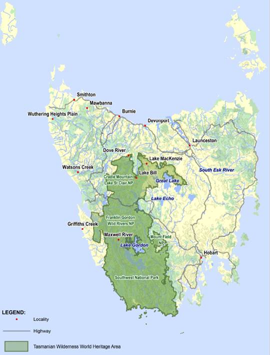
Source:
Parliamentary Library
1.13
The TWWHA is one of the largest temperate natural areas in the southern
hemisphere and is recognised as a World Heritage property for its Outstanding
Universal Value (OUV). It contains significant natural and cultural heritage,
including a wide range of plant communities (flora). Two‑thirds of
Tasmania's endemic higher plant species occur only in the TWWHA, and many
species provide living evidence of the Gondwanan origin of the Tasmanian flora.
Some species are representative of plant communities that once dominated
mainland Australia.[5]
1.14
The Parks and Wildlife Service, Tasmania (PWS) describes the TWWHA as
'the Australian stronghold of cool temperate rainforest'. Some vegetation
species in these forests date back over 60 million years and were once dominant
components of the vegetation across the Australian continent (before the
arrival of the eucalypts and acacias that now dominate the Australian flora). The
ancestors of many rainforest species—such as myrtle-beech, native plum and
leatherwood—evolved on the ancient continent of Gondwana. Many rainforest
species are extremely fire sensitive and can take 400 years or more, in the
absence of any further fires, to recover to their former glory after fire.[6]
1.15
According to the PWS, the TWWHA also hosts 'the most extensive and
pristine areas of alpine vegetation in Australia'. The dominant species are
shrubs, rather than the tussock grass and herb-dominant communities of the mainland
Australian Alps. About 60 per cent of the alpine flora is endemic to Tasmania. These
include such species as cushion plants, scoparia and Tasmania's only native
deciduous species, the deciduous beech. This alpine environment is extremely
fragile and susceptible to damage from fire.[7]
1.16
Most of Tasmania's unique conifers occur within the TWWHA: the second
longest lived organism in the world, the Huon pine; and the sole
representatives of the family Taxodiaceae to be found in the southern
hemisphere, the endemic King Billy pine (Athrotaxis selaginoides), the Pencil
Pine (Athrotaxis cuppressoides) and their natural hybrid, Athrotaxis laxifolia.
Like rainforest species, these conifers are highly susceptible to fire and in
some areas, extensive stands of dead 'stags' bear testimony to the ravages of
previous fires. Some species will never recover from burning.[8]
1.17
Moorlands are found throughout the TWWHA, with the sedge (buttongrass)
being the dominant species. The buttongrass moorlands contain over 150
vascular plant species, a third of which are endemic to Tasmania. Buttongrass
moorlands have a high frequency of fire and as a result, the acidic peat soil in
which they grow is among the most nutrient poor in the world.[9]
1.18
The TWWHA also provides secure habitats for some of the most unique
animals (fauna) in the world, as well as endangered species. Tasmania
and the TWWHA have a high proportion of endemic fauna, including five species
of mammal. Over half of the mammal species are a distinct subspecies from their
mainland counterparts. The TWWHA is also home to the three largest carnivorous
marsupials in the world: the Tasmanian devil; the spotted-tail quoll; and
eastern quoll. Endangered species within the TWWHA include species that have
recently become extinct or threatened on the mainland, and rare and threatened
species within Tasmania—such as the orange‑bellied parrot and the white
goshawk.[10]
1.19
In addition to its flora and fauna, the TWWHA is recognised for its
heritage values. These include: some of the richest and best preserved
Indigenous sites in Australia dating back around 45000 years; an 'outstanding'
example of one of the most significant features of world population movement in
the 18th and 19th centuries (the Macquarie Harbour
Historic Site); a profusion of complex and well‑exposed geological
features; and the most significant and extensive glacially modified landscapes
in Australia.[11]
1.20
Further, the TWWHA is important to Tasmania's culture, identity and
economy.[12]
For example, in 2008 a report commissioned by the (then) Department of the
Environment, Water, Heritage and the Arts estimated that Tasmania's World Heritage
Areas contributed $721.8 million in annual direct and indirect state output or
business turnover, $313.5 million in annual direct and indirect state value
added, and 5372 direct and indirect state jobs.[13]
The 2016 bushfires and their estimated impact on the TWWHA
1.21
Bushfires are a part of Australia's natural environment. Compared to the
mainland, Tasmania has relatively infrequent fire weather and high intensity bushfires.
However, these fires can occur throughout the fire season (December to March).[14]
1.22
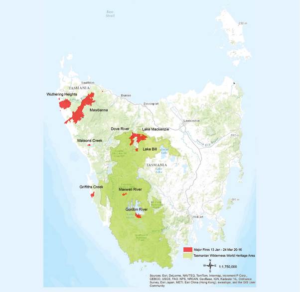
In January to February 2016, Tasmania experienced a series of dry
lightning strikes (commencing on 13 January). Fire authorities responded to
2350 incidents, including 639 vegetation fires. Of these fires, eighteen affected
the TWWHA, burning out approximately 19 936 ha (1.3 per cent).[15]
The majority of the burnt area was at Lake Mackenzie (13 822 ha), Mt
Cullen or Gordon River Road (3520 ha), and Maxwell River South (1389 ha).[16]
Figure 1.2: Major fires in Tasmania, 13 January to 24
March 2016
1.23
According to the Tasmanian Government, the majority of the burnt area
was composed of vegetation types and fauna that are adapted, or resilient, to
the effects of fire, and are therefore likely to recover to something similar
to their original state.[17]
Vegetation with high ecological
value
1.24
The Tasmanian Government identified the Mersey Forest Complex fires on
the alpine and sub-alpine vegetation around Lake Mackenzie as having the most
significant potential impact to vegetation values in the TWWHA:
The most significant flora value affected is Pencil Pine (Athrotaxis
cupressoides). This species is an iconic example of Gondwanic legacy in the
TWWHA, identified under World Heritage Criteria (ix). It also contributes to
the aesthetic importance of the alpine landscapes of the TWWHA identified under
World Heritage Criteria (vii). The recovery of cushion moorlands, various
alpine heathlands and sedgelands and alpine sphagnum peatlands will be
dependent on the fire intensity and degree of organic soil loss.[18]
1.25
Pencil Pine is classified as a 'threatened native vegetation community'
under the Nature Conservation Act 2002 (Tas).[19]
An estimated 141 ha of Pencil Pine forest and woodland are potentially impacted
by the bushfires, representing 'approximately 0.6% of the mapped distribution
of this species'.[20]
Figure 1.3: Aftermath of bushfires, Lake Mackenzie
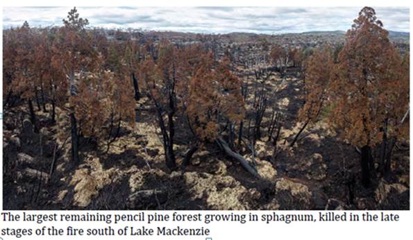
Source: Rob Blakers, Submission 21, p. 9.
1.26
The fires are expected also to have affected geoconservation features (organic
and mineral soils, karst and fluvial systems, wetland peats, cushion moors and
sphagnum bogs).[21]
Some of these—organic soils and karst systems—are recognised as part of the OUV
of the TWWHA.[22]
Navigation: Previous Page | Contents | Next Page