Chapter 3
Basin state issues
Introduction
3.1
This chapter examines issues relevant to specific basin states that were
identified in submissions and during hearings. The chapter concludes with a
number of related recommendations.
3.2
The basin is defined in Section 18A of the Water Act 2007 and
includes all water resources within or beneath the basin, but does not include
groundwater that forms part of the Great Artesian Basin (GAB)[1] Under the Act, the Bureau
of Meteorology (BoM) is responsible for compiling, maintaining and publishing
water accounts known as the National Water Account.[2]
3.3
The National Water Account provides an 'account' of the previous years'
water resources management for ten nationally significant water regions:
Adelaide, Burdekin, Canberra, Daly, Melbourne, Sydney, Ord, Perth, South East
Queensland and the Murray–Darling Basin (MDB).[3]
Specifically, it provides information about water stores, water flows, water
rights and water use. It also reports on the volumes of water traded, extracted
and managed.
3.4
The Account's definition for the MDB region is:
...[A]ll the surface
water connected to the channel network and all the groundwater (excluding any
water in the GAB) located within the geographical boundaries of the MDB
specified by the Act, except:
-
the areas drained by the Snowy
Mountains Hydroelectric Scheme storages that are located inside the legal MDB's
boundaries
-
the towns of Port Elliot and
Middleton in South Australia.
Further, the
following elements are not included in the MDB region water account:
-
off-channel water storages, such
as landscape catchment storages (also known as farm dams) used to harvest
runoff and floodwaters (these constitute water abstracted before it reaches the
rivers or water owned by the users)
-
urban water systems at utility
level, irrigation systems and private water supply systems.[4]
3.5
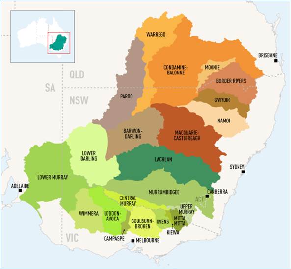
The Account divides the basin into 19 surface water planning areas and
22 groundwater planning areas. Figure 3.1 illustrates the individual basin
states with their corresponding catchment areas (groundwater planning areas).
Figure 3.1 The Basin catchments and states
3.6
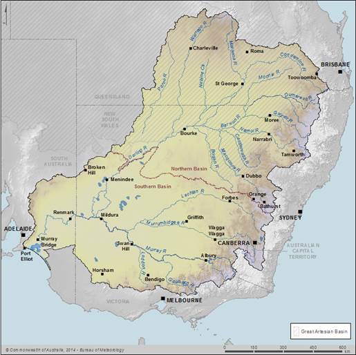
The MDB Account provides statements on groundwater and surface water
assets for the whole basin and by the two geographic divisions: the Northern Basin
and the Southern Basin[5]
(see Figure 3.2 for an illustration of the Northern and Southern Basins). The
boundaries for the two basins are determined by the physical geography of the basin,
previous water management boundaries and the level of hydrological connectivity.
Figure 3.2 The Northern and Southern Basins
Northern Basin
3.7
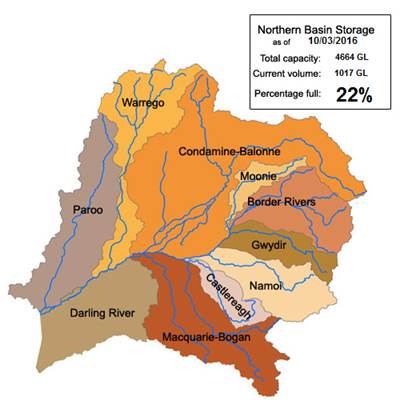
The Northern Basin comprises the catchment area of the Barwon-Darling
River and its tributaries upstream above the Menindee lakes. The Northern Basin
includes the Balonne, Moonie, Border Rivers, Macquarie, Gwydir, Namoi, Warrego
and Paroo systems. Figure 3.3 shows the catchments that comprise the Northern
Basin and includes the MDBA assessed public storage capacity of the Northern
Basin (4664GL) and the volume of water in storage (1017GL) as at March 2016.[6]
3.8
The river systems, land and water use, rainfall volumes and patterns,
topography and climate in the Northern Basin differ considerably from the
Southern Basin. The Northern Basin is much drier, having considerably less
rainfall that mostly falls in the summer months compared to the Southern Basin
which receives its rain in the winter time. The Northern Basin also has less
regulation, less development, and uses less water than the Southern Basin.[7]
3.9
Northern Basin water management is also characterised by a different
rules framework, fewer water storages, and more variable hydrological
connectivity when compared with water management in the Southern Basin.
3.10
Furthermore, some rivers in the Northern Basin, including the Paroo and
Gwydir, terminate in wetlands or swamps and only join major rivers in times of
flood.[8]
These are often referred to as 'closed' systems as they do not have continuous
flow into the Barwon-Darling system, and then into the Murray.
3.11
The MDBA's submission stated that because of these issues, the
management of the Northern Basin must also differ from that of the Southern
Basin.[9]
Figure 3.3 The Northern Basin
Committee hearing
3.12
The committee held its first public hearing in St George, Queensland, in
the Condamine-Balonne region of the Northern Basin. Witnesses shared their
personal stories of the implementation of the Plan, particularly emphasising
the effects of water buybacks in the valley and the flow-on effects on
businesses, towns and communities. The key Northern Basin issues discussed were
the Northern Basin review, buybacks in the Condamine-Balonne catchment,
over-recovery of water in the Macquarie Valley and the management of the
Menindee Lakes.
Northern Basin review
3.13
In 2012 the MDBA began a review of aspects of the Basin Plan in the
Northern Basin as the data for determining the relevant SDLs was not as strong
as the Southern Basin's data. The MDBA's submission states that the Plan
included SDLs for the Northern Basin and set local and shared reduction
amounts. The Plan determined extraction limits equal to a reduction of 390GL
average use by 2019. This amount is made up of both local reductions in each
valley and shared reductions, sourced from any valley in the Northern Basin.[10]
3.14
The MDBA's submission notes that the shared reduction amount for the
Northern Basin is 143GL, stating that this is used to 'achieve environmental
outcomes in the Barwon-Darling system.'[11]
3.15
The submission also noted that the review will assess whether the SDLs
in the region could be altered by undertaking socio-economic assessments,
environmental science projects and hydrologic modelling work.[12]
3.16
The two primary focuses of the Northern Basin review are:
-
Should any of the SDLs change
(with a focus on the Condamine-Balonne system and the northern zone shared
reduction)?
-
Should the apportionment of the
northern zone shared reduction change from the default specified in the Basin
Plan?[13]
3.17
The outcomes of the review will 'inform the water recovery program being
managed by the Department of Agriculture and Water Resources.'[14] This may
include the type and location of water entitlements to be recovered from the
Northern Basin.
3.18
Consultation for the review is being undertaken with representatives
from the Queensland and New South Wales state governments and with the Northern
Basin Advisory Committee (NBAC), which comprises Northern Basin community
members with knowledge and experience of the Northern Basin.[15]
3.19
The review is due to report in around April 2016, and will outline a
range of SDL options. Should any amendments to the Plan be required, the
committee notes that these would be subject to a formal statutory amendment
process.
Northern Basin Advisory Committee
(NBAC)
3.20
The Northern Basin Advisory Committee (NBAC) was established under the Water
Act 2007. It provides the MDBA with 'independent advice on how an adaptive
Basin Plan can be implemented in the Northern Basin.'[16] The committee
meets five times per year and has several working groups.
3.21
Its terms of reference include advising on the following matters:
-
development and implementation of
the northern basin work program;
-
proposals to achieve water savings
and/or improve environmental outcomes in the northern Basin through possible
changes to management and/or operational rules, including the need to address
third party impacts;
-
socioeconomic and cultural issues
of concern to the communities living in the northern Basin, and
-
any other matters relating to the
implementation of the Basin Plan in the northern Basin.[17]
3.22
The NBAC's Chair, Mr Mal Peters, stated in evidence given at St George,
that there is 'a huge diversity of opinion within [NBAC]'.[18] Mr Peters
was confident that NBAC's relationship with the MDBA would lead to better
assessments and modelling that would satisfy communities, and considered this
was a critical element of engaging with the community:
When the
socioeconomic work comes out, if communities cannot say, 'Yes, that looks to me
like it's fair dinkum,' it has been a waste of time. I am pretty confident that
will happen.[19]
3.23
Mr Peters gave an example from the Namoi region, whereby NBAC's work
with the MDBA had improved models and outcomes, and was therefore more likely
to be accepted by the community:
...[W]e worked pretty
extensively with the authority and picked up some of the models that we have
seen. In particular, there was a model that was developed in the Namoi
community. We are pretty confident that, when they unfold their socioeconomic
work, it will pass the pub test in the community.[20]
3.24
However, when the committee took evidence in Broken Hill the committee
heard from Mrs Karen Page, President of Menindee Regional Tourist Association
who stated that the Menindee region is not included in the Northern Basin
review, and that NBAC does not have a representative from the Menindee region.
Mrs Page indicated that the Menindee region was left out because it was caught
in the middle:
No. The Northern
Basin Advisory Committee is supposed to go from right up the top right down to
Menindee, but it does not actually include Menindee. Then you have got the
lower community consultative basin group that are down around Wentworth and
Merbein and beyond down to the Coorong, and they basically report on what is
going on down there. As I just said, we are in the middle.[21]
3.25
The committee recognises that Menindee is [as per Figure 3.2] in the
upper part of the Southern Basin. Nevertheless, this lack of consultation would
appear to run contrary to the intent of the Plan to manage consultation across
state borders.
Water recovery in the
Condamine-Balonne catchment
3.26
Under the Basin Plan, the Condamine-Balonne catchment has a required
local reduction of 100GL per year by 2019.[22] Approximately half of the
100GL reduction has already been achieved.
3.27
The MDBA's submission stated that during the preparation of the plan,
the local reduction for the Condamine-Balonne catchment was initially proposed
to be 150 GL. However, after further investigation, it was determined that
environmental targets could be met with a local reduction of 100GL:
...[A]dditional
scientific assessment and analysis commissioned by the Queensland government
together with remodelling by the MDBA showed that a local reduction of 100 GL
would still be likely to water the catchment’s key environmental assets such as
Narran Lakes.[23]
3.28
In addition, 143GL per year is required to be recovered from the
combined catchments in the Northern Basin, of which the Condamine-Balonne is
part.[24]
Water recovery through buybacks and
efficiency projects
3.29
Since the implementation of the Basin Plan, businesses or individuals
have been able to separate the water rights from land ownership, and sell the
water rights if they no longer wished to use the water. The sale of water to
the Commonwealth, colloquially called 'buybacks', has been one way that water
can be recovered from catchments for environmental use.
3.30
In 2015, the Water Amendment Bill capped at 1500GL the amount of
Commonwealth buybacks that could occur in any one year.
3.31
Water can also be 'recovered' through infrastructure projects that
improve water efficiency, reducing the volume of water required to deliver the
same crop or product.
3.32
Councillor Donna Stewart, Mayor of Balonne Shire Council, stated that in
the Condamine-Balonne catchment, some people have sold their water and exited
farming, while others have opted to improve infrastructure and water
efficiency:
Irrigators, of
course, have had the opportunity to sell their water. A lot of them have taken
that opportunity. Some have gone off and retired. Others have taken the
opportunity to invest in healthy headwaters, which helps them to make their
infrastructure more efficient, so in water efficiency projects. That is really
good—it helps keep production on the farms and keeps those jobs.[25]
3.33
The Condamine-Balonne catchment has experienced significant water
buybacks since the commencement of the Plan, about which witnesses at the
committee's hearing in St George had a lot to say regarding the impact that
this has had on local communities.
3.34
At the committee's final hearing, Dr Jacki Schirmer, an academic with
the University of Canberra's annual Regional Wellbeing Survey, stated that
although buybacks have been positive for two-thirds of irrigators selling
water, they have been negative for about a quarter of irrigators. Dr Schirmer
reported that a survey team was currently working on more detailed information
to determine how different communities have been impacted by buybacks.[26]
Impact of water recovery on
businesses in Dirranbandi and St George
3.35
The impact of water recovery in the Condamine-Balonne catchment was the
central issue raised during the committee's hearing in St George. Witnesses
stated that water recovery was having a significant impact on the economies of
St George and nearby Dirranbandi, and that while farmers had the right to sell
their water, the recovery of water did have severe, uncompensated impacts on
others in the towns and surrounding areas.
3.36
Businesses in the area reported that they had seen declines in revenue
and sales as farmers made commercial decisions to sell their entitlements and
farms and exited the industry. Mr Andrew McCosker, an employee at Dirran Ag
Spares, shared his family's experience of the direct correlation between
buybacks and revenue:
We started in 1998
and it consecutively grew every year. We have only seen a decline in our
revenue over the last two years and, to date, that is a 20 per cent decline in
our revenue since the buybacks have happened. The district has lost, as a
number, 30 per cent of our cotton growers. It is not hard to see why we have
seen that decline.[27]
3.37
Mr McCosker stated that if buybacks continued, his family's business
could possibly close:
...if these buybacks
continue like they have over the next two years, or if we lose another 30 per
cent of our cotton growers, it is quite possible that we will actually go
bankrupt.[28]
3.38
Businesses that directly support the local irrigation/farming industry
face difficulty when buybacks or any other commercial decision is made by those
that they have set their businesses up to service.
3.39
Mrs Samantha O'Toole, co-owner of Balonne Airwork, an aerial spraying
business shared her experience of building up her business to a successful
twelve-person, four-aircraft operation to service the surrounding irrigation
crops. However, when the water rights for a large cotton irrigation farm,
Balandool, were sold, Balonne Airwork lost 25 per cent of its activity, which
had a major impact on her business:
...[T]hen you get a
call out of the blue from a farm owner saying they have sold their water
licence and will no longer be growing cotton. That wipes 25 per cent off your
business straight up, so you go home that day and fire four people. That has a
huge impact on your business and on your long-term livelihood.[29]
3.40
Mrs O'Toole reported that Balonne Airwork had also undertaken
significant long-term investment based on predicted future business, including
purchasing and importing aircraft, which is now no longer required:
We bought a very
expensive piece of shiny equipment that is collecting dust at the moment—a 660
Thrush that we imported from the United States. We specifically bought that
piece of aircraft because it was high capacity, it was designed to do
high-volume work in big paddocks. It was perfect for Balandool. We specifically
imported that machine to take on a contract at Balandool. But now that machine
is just sitting there—an $800,000 dust collector for which we carry the debt
for a long term.[30]
Impact of water recovery on the
community in Dirranbandi
3.41
In addition to the impact on businesses, witnesses noted that the
population of Dirranbandi is decreasing, and attributed this to the buybacks.
Cr Stewart noted that enrolments at the local state school in Dirranbandi had
decreased, as had the overall population of the town.[31]
3.42
Mr Bruce Connolly, a private farming contractor, moved to Dirranbandi as
it began to boom in 1997 and shared how the town's population had risen and
fallen over the years:
I saw the town rise
from a population of approximately 300 through to 1,200 to 1,500 during busy
periods and then fall back to what it is now, which is a static population of
roughly 400 or 450.[32]
3.43
Mr Connolly also commented on the social repercussions of the buybacks
and a declining economy:
The panel asked about
suicide and depression and other social issues.
...If you take away
jobs and people's reason to get out of bed in the morning, it will not get
better.[33]
Potential impact of additional
shared reduction limit on the Condamine-Balonne catchment
3.44
Cr Stewart commented that the current impacts of water recovery in the
catchment were difficult to bear, and questioned the ability of the catchment
to recover the 100GL target, let alone contribute to a portion of the 143GL
shared reduction limit:
...100 gigalitres is
our contribution. We are about halfway there and we also have to contribute to
a further shared zone with the Goondiwindi region. That is about 143 gigs. We
cannot do it—we are scrambling to get to 100. Our communities just cannot bear any
more water buybacks in the Lower Balonne.[34]
3.45
Cr Stewart stated that water recovery seems to be focused on the area
from St George downstream to the end of the catchment. Cr Stewart argued that
the impact could be spread throughout the Condamine-Balonne catchment:
There are
opportunities to buy water from up the top. Up to 20 gigalitres have been
identified. The travesty is that all the water so far has been bought from St
George down. The Condamine-Balonne is probably 1,000 kilometres long in
Queensland, so why should 200 kilometres make the whole contribution, and why
should the communities down here bear the full impact of that water buyback?[35]
Committee view
3.46
The committee is keen to ensure that communities in the Northern Basin
are adequately consulted during the Northern Basin review and any subsequent
adjustments to water recovery requirements. The committee urges MDBA to consult
clearly and broadly with communities during this period and following the
review. In this vein, the committee notes that the NBAC provides a valuable
conduit between Northern Basin communities and the MDBA.
3.47
However, the committee urges MDBA to ensure the Northern Basin review
assesses the entire Northern Basin, and the adjoining regions (such as the
Menindee region) that are highly dependent on the outcomes of upstream water
management decisions. This should include representation from the Menindee
region, whether in the review or on NBAC or both.
3.48
The committee is aware that buybacks can have significant and ongoing
impacts on irrigators and the wider community.
3.49
The committee unequivocally upholds farmers' rights to sell their water.
Nevertheless, the committee heard from many people whose families and
businesses have struggled as a result of water buybacks, particularly around St
George and Dirranbandi. While farmers have acquired monetary value for their
water entitlement and are able to exercise the right to sell the entitlement,
surrounding communities and businesses do not receive such support.
3.50
The committee is concerned that the Condamine-Balonne catchment has a
very high recovery requirement, which it may not be able to meet, and which may
have serious consequences for towns such as St George and Dirranbandi.
3.51
The committee is of the opinion that water recovery in the Northern Basin
and within the Condamine-Balonne catchment could possibly be more equitably
spread so as to prevent any further impacts on St George and Dirranbandi. Given
the impacts of the buybacks on these towns, the committee is of the opinion
that further buybacks should be approached with caution and a full awareness of
the potential impacts on surrounding businesses and communities. This matter
merits further investigation by the MDBA as part of the current Northern Basin
review.
3.52
As such, the committee is of the view that any further reductions in
water entitlements should not occur until the Northern Basin review, and any
subsequent assessments to be made by MDBA and the Department of Agriculture and
Water Resources, have been completed.
Recommendation 1
3.53
The committee recommends that no further reductions in water
entitlements occur until the Northern Basin review, and any subsequent
assessments, have been completed.
3.54
The committee recommends that the review should also consider alternative
means of water recovery, particularly in the Condamine-Balonne catchment, in
order to minimise the economic and social impact of the Plan in the Northern
Basin. This would include consideration of the following options:
-
recovery of water upstream of Beardmore Dam;
-
use of private storages to more efficiently store environmental
water and reduce evapotranspiration (the sum of evaporation and plant
transpiration) losses;
-
implementation of environmental works and measures to more
efficiently delivery environmental water to key environmental assets; and
-
temporary trade of water to make best use of Commonwealth water
assets when environmental needs have been met.
Recommendation 2
3.55
The committee recommends that the Murray-Darling Basin Authority, as
part of its ongoing social and economic work, undertake and publish a thorough
assessment of the estimated and actual social and economic impacts of the
implementation of the Plan, including of pursuing the remaining water recovery
for the Condamine-Balonne catchment and other similarly distressed areas.
Macquarie Valley
3.56
Water recovery is specified in the Plan on a valley-by-valley and
whole-of-system basis, and therefore water extraction in some valleys will
occur in greater volumes than the valley requirement in order to make up the
whole-of-system requirement.
3.57
However, witnesses argued that the Macquarie Valley does not have
significant flow through to the Murray River. Mr Ashley Wielinga, General
Manager, Warren Shire Council, stated that the river is an example of a closed
or terminal system, which has limited flow through to the Barwon-Darling and
Murray systems:
The Macquarie...it has
only got about a 10 per cent throughput at the bottom end. It is basically to a
large degree a terminal system...[36]
3.58
In these terminal or closed systems, while water recovery may benefit
the valley and environment locally, it may not have a significant impact on the
Murray River and the overall basin. Mr Egan, Chair of Macquarie River Food
& Fibre also argued that this is the case for water recovered in the
Macquarie Valley:
The connectivity to
the Barwon is, basically, one year in 10, so flows out of the dam do not count
as far as getting water to the Darling.[37]
Over-recovery of water
3.59
The committee heard evidence of over-recovery of water in the Macquarie
Valley. Mr Wielinga, General Manager, Warren Shire Council, a local government
area in the Macquarie Valley, stated that there was an initial discrepancy in
the water recovery figure for the valley:
When the Basin Plan
research was done, they put out a guide to the Basin Plan. For our valley, the
guide to the Basin Plan said it needed 20 gigalitres in-valley. By the time the
plan came out, it said 65 gigalitres. I had the opportunity to visit Canberra
and went through the modelling with the authority. Guess what the modelling
said? It said 19 gigalitres.[38]
3.60
Mr Wielinga indicated that despite the in-valley requirement for
recovery of 65GL of water, far more than this has been purchased in the valley:
...I believe the purchases
are 48 gigalitres by the New South Wales state government and 126 gigalitres
for general security by the Commonwealth Environmental Water Holder. So all up
174 gigalitres of general security water has been purchased by the
Environmental Water Holder.[39]
3.61
Mr David Duncan, Consultant, Macquarie River Food & Fibre, stated
that the water recovered is about 30 per cent of the total general security
entitlement in the valley.[40]
3.62
Furthermore, the Macquarie Valley has been the primary focus of water
recovery in its region. In particular, as in the Condamine-Balonne catchment,
the majority of the water has been recovered from a small area of the
catchment:
All of the water that
they needed to recover from, what they considered, out of the whole system—so
if you look at that front map in the document you have, they have recovered all
of the water from Narromine down to Marebone in the blue zone. Everything was
covered out of that little area for that whole map. So we have been unfairly
targeted, because they wanted regulated water only. All of the other river
valleys were not included.[41]
Potential impacts of over-recovery
3.63
Over-recovery of water has the potential to cause social, economic and
environmental damage to local communities. Mr Egan argued that over-recovery in
the Macquarie Valley provides little environmental benefit to the valley and
the Macquarie Marshes:
...There is not enough
water left in the system, because we now have a low reliability—and
environmentally we are actually loading the Macquarie Marshes up with salts. We
are saying that we lose on all three accounts.[42]
3.64
Further, Mr Egan stated that while the purchase of water was positive
for some landholders, the recovery of that water will have negative impacts for
the environment:
The cost on the
temporary water market is about 15 mil. This is a direct transfer of wealth,
fully government funded, at no cost to the beneficiaries. It is a short-term
gain for a few rangeland graziers. But the extra salt loads in the marshes will
create a long-term disaster.[43]
3.65
Mr Egan concluded that 'the only real solution is for the government to
surrender over-recovered water.'[44]
Committee view
3.66
The committee is concerned that over-recovery of water in certain areas
is a key issue while noting that recovery in some areas may need to exceed the
valley-by-valley requirement in order to make up the whole-of-system
requirement.
3.67
However, the committee is of the opinion that water recovery in areas
with low connectivity to the Barwon-Darling and Murray Rivers may do more harm
than good. The committee is concerned that this may be occurring in the
Macquarie Valley, and other closed or terminal systems such as the Gwydir
Valley.
Recommendation 3
3.68
The committee recommends that the MDBA address the existing
over-recovery in the Macquarie Valley and other ‘terminal’ systems such as the
Gwydir Valley, with a view to limiting recovery to amounts which address
valley-specific environmental needs.
Southern Basin
3.69
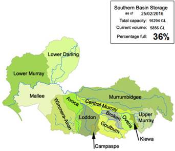
The Southern Basin comprises the catchment area of the Lower Darling
River, the Murrumbidgee, the Murray River and its tributaries (the River Murray
catchment is split into 3 sections — upper, central and lower). Figure 3.4
shows the catchments that comprise the Southern Basin and includes the current
MDBA assessed storage volume of the catchment at 25 February 2016 together with
its expected total basin plan storage capacity of 16 294GL.[45]
Figure 3.4 Southern Basin
Committee hearing
3.70
The committee conducted its second public hearing in Broken Hill, NSW,
near the Menindee Lakes, and flew over the lakes following the hearing to
gather an aerial perspective. Witnesses at the hearing highlighted the
economic, social and environmental importance of the lakes to the region
particularly on the fresh water supply aspect of Lakes, which are fed by the
Darling River from the Northern Basin.
3.71
The third hearing was held at Griffith in the heart of the Riverina
irrigation district of NSW in the Murrumbidgee catchment.
Menindee Lakes
3.72
The Menindee Lakes is a system of seven large natural ephemeral lunette
lakes in the Lower Darling catchment that were modified to allow for water
storage in the 1960s. The water from the lakes is used for both urban supply in
towns such as Broken Hill, and irrigation water for nearby landholders.[46]
The lakes are also used recreationally by locals and are a tourism drawcard for
the region.
3.73
The lakes are shallow and located in a hot, windy and dry region, making
them particularly susceptible to drought (leading to low inflow) and
evaporation. It is estimated that they lose an average of 400GL of water per
year, and even up to 560GL in dry, hot years. The MDBA's submission stated
that:
Even with only
minimum releases from the lakes to meet downstream requirements, unless there
are flows coming in from upstream, the lakes run out of water within three
years.[47]
3.74
The water levels in the lakes are currently quite low. This is primarily
due to low rainfall and low inflows into the lakes from further up the Darling
catchment. Furthermore, one witness stated that long-term weather forecasts do
not indicate any upcoming serious rains. Cr Dave Gallagher, Deputy Mayor,
Broken Hill City Council, stated that the current situation is more severe than
during the Millennium Drought:
It is my
understanding that the inflows are at their lowest level in the recorded
history of these readings, even lower now than they were during the Millennium
Drought, and there are still no significant rains as far as the long-term
weather forecasts can tell us. So we are facing potentially a much more serious
situation than we did then.[48]
Management of the lakes by NSW
government
3.75
The Menindee Lakes water storage is owned by the NSW government and
operated by Water NSW. The NSW government makes all decisions related to the
operation of the lakes, and the storage and release of water. Water releases
can occur from the lakes back into the Darling River once particular 'trigger'
levels are reached.
3.76
The MDBA's submission outlined the role of the NSW government in
relation water releases from the lakes:
NSW has a
longstanding agreement with Victoria, South Australia and the Australian
Government to share some of the water in the lakes when they are above certain
“trigger” levels. When the lakes volume rises above 640 gigalitres and until it
drops below 480 gigalitres, the water can be shared to support the River Murray
system.[49]
3.77
The MDBA's submission also outlined its own role with regard to water
releases from the lakes:
The MDBA, which
operates the River Murray on behalf of the basin governments, is allowed to
place orders for NSW to release water when trigger levels are exceeded. During
those periods, NSW also releases water from the lakes to meet its own local
needs.[50]
3.78
The MDBA's submission stated that any amendment to the current
management arrangements would be a decision for NSW, in agreement with the
other basin states.[51]
Broken Hill water supply
3.79
Menindee Lakes provides urban water supply to Broken Hill, and water
security and quality is a key issue for residents. Councillor Marion Browne,
from Broken Hill City Council, outlined the severe water supply problem that
the city is facing due to a lack of water security:
As a city of 19,000
people, we cannot survive without a secure water supply, and at the moment that
security is in question. The lakes are in crisis. We are currently on level 2
water restrictions with a strong possibility that by summer this will have
advanced to level 4.[52]
3.80
Broken Hill has relied on water from the Darling River, supplemented by
water from local reservoirs in years with high rainfall. Councillor Browne
expressed concern that emergency water supply measures, including bore water,
and poor quality water from the lakes, might become permanent measures:
It is a matter of
great concern to many in the community that we now face the prospect in this
emergency of having to use bore water, supplemented by increasingly saline
water from those parts of the lakes where the remaining dwindling supplies have
been stored. The council's position is that the bore water option is strictly
an emergency measure and not acceptable as a permanent alternative.[53]
3.81
Cr Browne also commented on the importance of water in making the town
more habitable for residents:
We live in a
lead-filled desert environment, so the prospect of not having water for parks,
gardens, street trees or evaporative cooling is not to be contemplated.[54]
3.82
Furthermore, there have been discussions about a pipeline from another
river, such as the Murray, to provide urban supply in Broken Hill and therefore
reduce evaporation from water stored in the lakes. The committee heard that
while this may improve water security for Broken Hill, Cr Brown stated that the
lakes have both environmental and cultural importance to the region:
They are an essential
recreational outlet for Broken Hill people. They are important environmentally.
They are important culturally to the Aboriginal people of the area, so to me
that would be the risk with that option. We would need to have some guarantee
that the nature of the lakes would not be drastically changed as a result of
that. It is not a secondary importance—it is as important as the water supply
itself.[55]
Measures to improve water security
and the health of the lakes
3.83
The council put forward several recommendations to improve the Menindee
Lakes and the water supply for Broken Hill, including:
-
raising the trigger point for releases from the lakes;
-
commencing already agreed-upon infrastructure works; and
-
nominating the Menindee Lakes as a Ramsar [56]
or iconic site.[57]
Raising the trigger point for
releases from the lakes
3.84
As stated above, the current 'trigger point' for water releases, as
agreed by the basin states and Commonwealth Government, is set at 640GL (and
water can continue to be released until the level drops below 480GL).
3.85
However, Broken Hill City Council recommended that current trigger point
be 'set at a minimum of 640GL for NSW control' and above 800GL before the MDBA
can place orders for water releases with NSW.[58]
3.86
The council specified the 800GL figure as it is the amount used in
Broken Hill and the amount that can be stored in the area – and therefore would
secure Broken Hill's water supply.[59] The council stated that
it had come to this figure by drawing on local knowledge and experience:
It is from experience
and from speaking to people about the options that we have, and from years and
years of knowledge in that area—not from myself, but from other people.[60]
Commencement of already agreed-upon
infrastructure works
3.87
The council discussed the need for infrastructure works to improve the
holding capacity of the lakes and the ability for operators to move water
between lakes as required. The council advised that a program of works had been
agreed to in July 2010 in a Memorandum of Understanding (MoU) by the then Prime
Minister Julia Gillard and the then Premier of NSW Kristina Keneally.[61]
3.88
These works would deliver an outlet regulator from Menindee and Block
Dam between Lake Menindee and Lake Cawndilla. Although these key works were
agreed to in the MoU, they have not yet commenced.
3.89
The council sought guarantees for the commencement of these works, as
they would provide significant benefit to the lakes and the surrounding
communities:
The purpose of these
engineering works would be to keep more control of the water in the lakes and
to reduce evaporation losses by containing the water within a smaller area.[62]
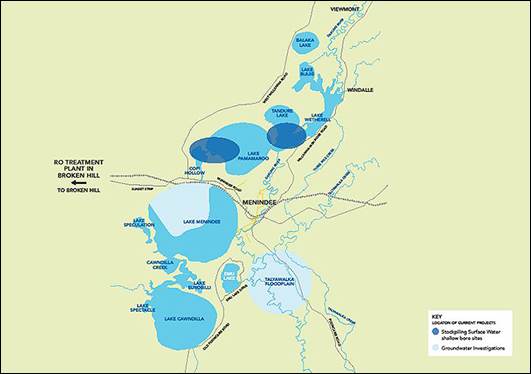
Figure 3.5 Menindee lakes, NSW[63]
3.90
WaterNSW presently states that it is recommissioning the Broken
Hill desalination plant to treat the remaining surface water supplies in Lake
Menindee by November 2015:
...Reverse osmosis will
be required to treat the remaining surface water supplies in Lake Menindee by
November 2015. Work is currently underway to recommission and upgrade the
desalination facility in Broken Hill to extend the use of all available surface
water sources from the Menindee Lakes.
Desalination will not
be needed if there are significant inflows from rainfall to replenish the
Menindee Lakes system before this time. Up until then the surface water that
remains in the Lakes will have increasing levels of salinity.
The recommission and
upgrade of the existing desalination plant in Broken Hill is now underway to
extend the use of all available surface water sources. Reverse osmosis may also
be required to treat water sourced from groundwater beyond 2015, if it is
required.[64]
Ramsar or iconic site nomination
3.91
Further, the council and some other submitters sought the nomination of
the Menindee Lakes as a Ramsar or iconic site, which would also lead to more
water being retained in the lakes. Ramsar nomination is a state process and
would need to be initiated by the NSW Minister for Water.[65]
3.92
Cr Browne noted that the lakes are very important to Menindee and its
tourism, and therefore it is important that they continue to be well managed
for multiple uses:
For Menindee...the
environmental aspect of the lakes is very important. Acknowledging the fact
that it is not an entirely a natural site, it is still a very important site
for Menindee tourism, as I am sure the Menindee people will say. The amenity of
the lakes is a really important part.[66]
3.93
Furthermore, Cr Browne indicated that there are no iconic sites on the
Darling River and argued that the river should be recognised for its
environmental and recreational value:
We are conscious that
there are no iconic sites on the Darling River itself. It is our belief that
the Darling River needs to be recognised as an important environmental asset as
well as recreational in other senses.[67]
3.94
As such the Council stated that it would support the nomination of the
Menindee Lakes as a Ramsar site:
Council is certainly
supporting the idea of recognition, which would give some priority to the
environmental aspects of the lakes, and that is something we are pursuing.[68]
Committee view
3.95
The committee is cognisant that the issues raised by the Broken Hill
City Council and other submitters with regard to the Menindee Lakes fall within
the jurisdiction of state governments, in concert with the federal government
where appropriate. Further, the committee acknowledges that lakes are owned by
the NSW government and operated by Water NSW.
3.96
However, the committee views urban water supply security as crucial, and
accordingly, is of the opinion that water security and infrastructure to
improve the lakes are matters that should be urgently addressed. The committee
therefore urges federal and state governments to examine options for securing
Broken Hill's water supply, including raising the trigger point for releases
and improving infrastructure and storage at Menindee Lakes. The committee notes
that in examining options, governments would consider the possibility of less
water flowing out of the lakes, and the potential impact this may have on
downstream communities and environments.
3.97
The committee also acknowledges the importance of the Menindee Lakes as more
than just water storage; the social, cultural and environmental benefits of the
lakes are of considerable importance to the local communities. For this reason,
the committee supports continued management of the lakes for these multiple
uses.
3.98
The committee also urges MDBA to consider an environmental watering plan
for the Menindee Lakes.
Recommendation 4
3.99
The committee recommends that federal and state governments examine
options for securing Broken Hill's water supply as recommended by the Broken
Hill City Council, including raising the trigger point for releases, and
improving infrastructure and storage at Menindee Lakes.
Recommendation 5
3.100
The committee recommends that an environmental watering plan be developed
for the Menindee Lakes, provided that Adelaide's water supply and that of South
Australian irrigators and landholders dependent on the Murray, is secure (see
paragraph 3.197).
New South Wales
Committee hearing
3.101
4.68 The committee conducted its third hearing in Griffith in the heart
of the Riverina irrigation district of NSW in the Murrumbidgee catchment.
3.102
The key issues raised in the hearings were the impact of the removal of
water for agriculture via water buybacks, as in St George, the impact this was
having on the agriculture sector and associated service industries.
3.103
Cr Hogan provided the committee with an overview of the nature of the
region and its industries reliant on water from the region's main rivers:
...[W]ater and
irrigated agriculture is the lifeblood and key economic and social driver of
our RAMROC[69]
region. A large part of our region comprises irrigated
food-and-fibre-production towns and communities in the river valleys of the
Lachlan, Murrumbidgee and Murray.[70]
3.104
The Plan has had a significant impact on the RAMROC region, particularly
the Commonwealth water buybacks Cr Hogan claimed:
Communities in our
region have been adversely impacted, both economically and socially, as a
result of the Commonwealth Water Act 2007, which initiated significant issues.
One of the largest ones is the Swiss-cheese style buyback of landholders' water
entitlements and, subsequently, adopting the Murray-Darling Basin Plan, which
provides for the diversion of 2,750 gigalitres of water currently used for
productive purposes. You just cannot take that amount of water away from these
valleys and not have an enormous impact.[71]
3.105
However, Cr Hogan did express satisfaction with the Water Act 2007
Amendments passed in 2015 and the recent amalgamation of Commonwealth
departments with responsibility for water and agriculture:
We are pleased that
in recent months there have been two positive actions taken by the Commonwealth
government. Firstly, there is the legislation to cap water buybacks at 1,500
gigalitres. Secondly, there is the most recent and common-sense decision, which
is to merge the portfolios of agriculture and water resources under one
ministerial portfolio.[72]
3.106
A number of individuals expressed dissatisfaction with the allocation of
water for the environment. Many mentioned that they had all been through the
process of water sharing before the advent of the MDB and now felt worst off.
3.107
The Chair noted these concerns and stated that 'there are two aspects
that we are primarily zeroing in on. One is the loss of water to agriculture
and the impact that that has...the other aspect of it is, to the extent that the
environment has received a greater volume of water, has that actually benefited
the environment?'
3.108 Cr Peter Laird,
Mayor, Carrathool Shire Council, stated that in his opinion it had not:
They jump up and down
about the Cumbung Swamp but historically it is a drying lake for periods of
time and then it gets flushed in other periods of time. The Lachlan does not
flow into the system. Unfortunately some of the people at the time said, 'Well
there is money coming from the federal government; let's grab the money and
agree that it does flow in.' But historically the Murrumbidgee, when it is in
flood, flows back into the Lachlan; the Lachlan does not flow into the
Murrumbidgee. Our problem was that people were out to grab the money that was
on offer rather than say we would not want to be part of the Murray-Darling
Basin. And they over bought in the buybacks too.[73]
3.109
Cr Laird had previously mentioned the increased environmental flows in
the Lachlan river:
The volume of water
that they send down the Lachlan is eroding the banks over time. It is just
unbelievable...[74]
3.110
Significantly, over the course of the hearings the committee noted a
familiar theme regarding suggestions to ameliorate the environmental flow
issue—upper stream states would invariably suggest remedies for downstream
states while downstream states would offer similar advice for their up stream
counterparts.
3.111
Cr Dal Broi stated that:
We believe that we
have lost up to 30-odd per cent of our water from this area to the
environment—totally unacceptable. [75]
3.112
Cr Hogan outlined what the main issues were for the RAMROC:
(1) the need for the
Commonwealth Act to be appropriately amended to fully enshrine the essential
triple-bottom-line balance between the environment, social and economic
criteria, and outcomes; (2) the lack of meaningful intent or progress that has
been made by the Murray-Darling Basin Authority in assessing the social and
economic impacts of the Basin Plan on communities, businesses and residents
throughout the basin region; (3) the absence of measurable or quantifiable
evidence, in relation to the environmental benefits that have been achieved,
particularly the lack of any cost-benefit analysis of the environmental outcomes;
(4) council and community concerns regarding the Basin Plan Constraints
Management Strategy, particularly the potential adverse impacts on urban
infrastructure, like businesses' downstream agricultural properties and
landholder families; (5) environmental water flows and delivery thereof,
river-channel capacity and over-bank flooding strategies—unfortunately, the
authority has a fixation on the only way to get water into swamps or wetlands
being an over-bank event; (6) the potential for improved water management of
the Coorong, Lower Lakes and Murray Mouth to reduce high evaporation levels
and, potentially, free-up more water for productive purposes.[76]
Victoria
3.113
The committee held two public hearings in Victoria, in Echuca and
Shepparton. In Echuca, the committee heard from witnesses from both Victoria
and New South Wales, including representatives from local councils, irrigators,
landholders, businesses, food processors and the Murray Darling Association. In
Shepparton, the committee heard from representatives of the local council,
dairy industry, environmental groups, landholders and local businesses.
3.114
The key issues raised in the hearings were water distribution, and the
Goulburn-Murray Water Connections Project. The most pressing issues raised by
landholders and community leaders in Shepparton were the constraints management
strategy, loss of water and the ongoing social and economic impacts (see
Chapter 4).
Constraints management
strategy–delivering environmental water
3.115 The MDBA
released its Constraints Management Strategy (CMS) in November 2013 noting that
the Basin Plan Sustainable Diversion Limits (SDLs) were determined based on the
existing physical characteristics and river operations in the Basin:
The SDLs return part
of the water that was previously supplied for consumptive use (primarily for
irrigation at regulated flow levels from spring to autumn) to the environment
for use throughout the year in line with environmental water entitlement
holdings. Environmental watering is delivered right across the year – not all
at once, not all in one place. Water comes from all over the Basin, not just
from one or two dams; and contributes to significant local and downstream
outcomes.[77]
3.116 As such, the
strategy 'identifies and describes the physical, operational and management of
constraints that are affecting environmental water delivery'.[78]
These constraints are river rules, practices and
structures that not only govern the volume and/or timing of regulated water
delivery through the river system but also look for continuous efficiencies
that can improve the flow.
3.117 As indicated
above, the Plan is said to be capable of being delivered within existing
constraints; however state governments requested a constraints management
strategy be included in the Plan:
Governments requested
a constraints management strategy be included in the Basin Plan – reflecting
community concern about the importance of environmental water and being able to
deliver it without adversely affecting landholders and communities.[79]
3.118
When the MDBA released the strategy in November 2013, it also released a
report on feedback from community consultation and how this influenced the
final CMS:
The MDBA agreed to
undertake the early investigation work required under the strategy on behalf of
the state governments, including the consultation with communities and
investigation of the target flows set by the states. This involved gathering
local information through input from landholders about concerns and effects on
their riverside land, as well as technical work on water flows and inundation,
and identification of the mitigation options and their likely cost.[80]
3.119
In preparation of business cases on constraint areas, some state
governments have taken the lead; others have requested the MDBA to complete
this work. In all instances, any decisions taken 'to change river constraints
will be collectively decided by the state and Commonwealth governments by 30
June 2016.'[81]
3.120
Consultation with communities has involved the preparation of draft
reach reports in 2014 and final reach reports in 2015 for each of the seven key
focus areas: Gwydir region, Murrumbidgee, Hume to Yarrawonga, Yarrawonga to
Wakool Junction, River Murray in South Australia, Goulburn River, and Lower
Darling.[82]
Community concerns about the impact
of overbank flows on properties
3.121
Many submitters and witnesses were concerned about constraints
management in the Goulburn River area, particularly the impact that overbank
flows (i.e. flooding) would have on private landholders and their businesses.
In particular, witnesses expressed concerns about the volume of the flows, and
their timing and duration.
3.122
Mrs Jan Beer, representing the Upper Goulburn River Catchment
Association, indicated that the proposed flows down the Goulburn River and its
tributaries would have significant impacts on local landowners:
The severe flooding
is the 20,000 to 30,000 megalitres per day that the MDBA are proposing. They
state that that is a small overbank flow and they have continually stated this
in documents. They say it will not exceed minor flood levels. That is rubbish,
as you have heard from people here. It is twice the channel capacity at
Molesworth.[83]
3.123
Mrs Beer stated that flows of this level would damage properties:
It completely
inundates properties. The entire river flat component of many properties would
be inundated. The floods come down; they rise very quickly; they fall very
quickly. But, if they intend to make releases from Eildon and this goes on to
the severe, frequent and prolonged, they are prolonging the flood, and that is
what keeps it backed up over properties and particularly in the tributaries.
There has been no work done on the tributaries at all to see what the impacts
are.[84]
3.124
Mrs Karen Williamson expressed concerns about the extent of the impact
of flows, stating that it has been difficult to determine the extent of the
flows as MDBA mapping has not been regarded as accurate by local residents. Mrs
Williamson also stated that there are some significant discrepancies between
MDBA's maps and local knowledge and experience:
It has only been in
the last fortnight that the interactive maps which are supposed to solve all
the problems have gone up. Andy and I have spent a lot of time doing
comparisons. We have had farms in three different locations in the district and
we have had local farmers tell us what happens at each level. We then went
through the interactive maps and we did comparisons, and that is in the mapping
you have there. Some of the mapping is more accurate than it was before, and
you will notice that, where it is more accurate to the farmers, you are looking
at up to 100 per cent inundation of their river flats. Where the mapping is
very different—in the first couple—there are some properties that show no
flooding at all in the interactive MDBA maps, whereas from photographs and
local input those properties are also inundated.[85]
3.125
Mrs Williamson stated that it is not just her property that would be
affected; rather farms throughout the district would be impacted. Mrs
Williamson indicated that inaccurate mapping may mean that the impact of the
flows are currently underestimated:
What we would like to
see is appropriate and correct map representation because, if the maps are
wrong, the impact potential is wrong and the cost estimates are wrong. Unless
the mapping is correct and the mapping includes the tributary behaviour,
everything else is incorrect.[86]
3.126
The impact on Mrs Williamson's property has been correctly represented
by the MDBA due to her persistence, however for other properties, the impact of
tributaries has not been taken into account:
...what they have not
done is: the flooding that you see in these is lacking the tributary flooding,
because when the Goulburn floods it pushes water upwards on the tributaries.
Often what happens is that the tributaries cut off the farmers from being able
to get their animals off the property. What you are seeing on their maps is
just an expansion of the Goulburn River. But what you are seeing on the owners
'maps is how that expansion then leads into the drains, gullies, channels and
tributaries and expands from different areas. You will also notice that on the
maps where is only water on half of the map, the other half is hill country. So
this is a complete inundation. It is not just an empty basin. It crawls around
and creates currents, and then it fills in the middle bit, basically.[87]
3.127
Mrs Beer stated that there had been no study of the tributaries at all.[88]
Where knowledge of volumes and/or mapping is incorrect or inconsistent, it is
difficult to accurately assess the potential impacts of overbank flow events.
3.128
Furthermore, there appeared to be a lack of awareness among some farmers
of the potential and impact of the flows.[89]
Consultation with MDBA
3.129
Witnesses also told the committee that consultation with MDBA was
lacklustre and witnesses had trouble getting MDBA to acknowledge and correct
errors in documentation.
3.130
One example of this was the suggested levels of overbank flows in
documentation, which locals in the Upper Goulburn River region insisted would
be high. Mrs Beer, representative of the Upper Goulburn River Catchment
Association, stated that despite these levels being untenable for landowners,
it was difficult to get this recognised by the MDBA. Mrs Beer indicated that
MDBA had acknowledged that the highest level was too high:
For the last two
years, we have told them that 20,000 megalitres is untenable and asked: would
they please remove it from the documents. They have acknowledged that it is
untenable; I think they say that in the document.[90]
3.131
However, Mrs Beer stated that the information is then fed back to
Canberra yet somehow is not included in future documentation, and the original
figure still remains:
It is edited; short
notes and dot points are made. It goes eventually to the ministerial council,
to the decision makers, but all the main information that we give them, our
concerns, seems to be filtered out somewhere along the line, because, when the
documents come back, there it is again.[91]
3.132
Mrs Beer reported that following community concern and pressure, the
MDBA had rewritten the Goulburn River reach report:
That was only because
we harassed them, argued for so many meetings and said, 'No, this is not right;
you have to rewrite it.' To their credit, they rewrote it.[92]
3.133
However, Mrs Beer stated that the rewritten report still had figures she
considered were too high, and did not take into account the water that would be
provided from tributaries or how high flows would dissipate:
It came back with
20,000 from Eildon to Molesworth and 30,000 from Killingworth down to Mitchelton.
The Yea tributary comes into that 30,000 area, which means that the higher the
Goulburn River is, the tributary is going to be backed up even more and it is
not going to be able to escape the water and so it stays up. So we just do not
seem to be able to get through, to be quite honest.[93]
3.134
At the committee's final hearing in Canberra, the Commonwealth
Environmental Water Holder, Mr David Papps, affirmed that he was aware of these
ongoing concerns, had met with people from the area and had reiterated that he
did not order water if it would flood private land.[94]
3.135
Mr David Parker, Deputy Secretary, Department of Agriculture and Water
Resources, also affirmed that if a landholder did not permit overbank flows on
their property, the water would not be released:
If the landholder
will not permit water to flow over their private property, then water would
never be released. We would not do the relaxation of it in any event.[95]
Cost of overbank flows
3.136
Landowners also stated that overbank flows incurred significant costs on
them by affecting their land and livestock.
3.137
In particular, for farmers whose land was primarily floodplain, the
potential for inundation was catastrophic. Mr John Canny, a farmer from
Molesworth, shared his situation whereby most of his property would be
underwater and therefore unfarmable and impossible to sell:
...my property is 85
per cent of flood plain. Forget all the mapping, we know that if we get 20,000,
85 per cent of my property is flooded... those flows will make our properties
unfarmable. And, if we put easements over them, they will be unsaleable as
well.[96]
3.138
In such events, farmers would have to agist their stock until the waters
receded, at considerable expense, and commit further time and money to
restoring pastures.[97]
3.139
Witnesses expressed concern that the funds set aside for constraints
management was inadequate, and that compensation for inundated land has not
been determined.[98]
Committee view
3.140
The committee notes that changes to river constraints will not be
decided by state governments until 30 June 2016. This should be clearly
communicated to individuals and communities who are concerned about proposed
flows being discussed under the CMS.
3.141
The committee was concerned by evidence regarding the potential flooding
of private land and expects the issue of liability for third party impacts from
such events to be clearly addressed with landholders prior to any events taking
place. There is also a possibility that environmental watering events may
impact on third parties; in these circumstances, the committee expects the
Commonwealth to assume liability for such impacts.
3.142
However, the committee is supportive of the commitment shown by the
Department of Agriculture and Water Resources and the Commonwealth
Environmental Water Holder in assuring landholders that their land will not be
flooded without their consent.
Recommendation 6
3.143
The committee recommends the Commonwealth assume liability for damage to
private property from environmental watering events, including to both
landholders and third parties, except to parties who have given prior consent
to such flooding.
Recommendation 7
3.144
The committee recommends that the MDBA and state governments address the
issue of third party impacts from environmental watering events during the
development of constraints proposals, and clearly communicate with landholders
who are likely to be affected by such events.
3.145
Further, the committee notes that the MDBA is undertaking some
consultation for the CMS on behalf of state governments and entities. While
MDBA's consultation with basin communities generally appears to have improved
in recent years, it is still concerning that individuals are having difficulty
identifying which level of government is responsible for particular aspects of
the Plan and its implementation, accessing information from MDBA, and having
their views heard and incorporated into MDBA planning.
Recommendation 8
3.146
The committee recommends that the MDBA review its communication methods,
particularly with regard to projects still in development such constraints
proposals, and improve its ability to incorporate the views of communities and
landholders into decisions and reports.
Goulburn-Murray Water Connections
Project
3.147
The Goulburn-Murray Water (GMW) Connections Project is the largest
irrigation modernisation project in Australia. Through an investment of over
$2 billion, it aims to 'create a more efficient automated water delivery
network in the Goulburn-Murray Irrigation District (GMID) to deliver improved
customer service levels.'[99]
3.148
The project originated in 2008 when the Victorian government committed
funding to the GMID to modernise the network. At this time it was called the
Northern Victoria Irrigation Renewal Project (NVIRP). In July 2012 the project
was integrated into Goulburn-Murray Water as the GMW Connections Project.[100]
3.149
It is jointly funded by the Commonwealth and Victorian governments. The
project is delivered by a dedicated project team that plans and designs the
connection solutions, and led by a General Manager who reports to the GMW
Managing Director.[101]
Objectives of the project
3.150
The GMID upgrade takes in northern Victoria between Swan Hill and
Cobram, and the Goulburn and Murray systems, which is often referred to as the
‘Food Bowl’ of Australia. The project will automate much of the water delivery
network, replacing ageing irrigation infrastructure.
3.151
The objectives of the project are:
- upgrading and
automating backbone channels and meters
- reducing the size
of the channel network
- reconnecting
properties to the upgraded backbone channel system through individual and
shared connections
- investigating and
delivering special environmental projects
- boosting regional
economies, and
- minimising the
increase in GMW infrastructure whole of life costs and customer prices.[102]
3.152
For irrigators, the project aims to enable water to become available almost
on demand, with consistent flow rates to assist in improving on farm
productivity. The project also provides environmental opportunities and
benefits through water savings.[103]
3.153
The project is required to deliver 429GL in water savings across the
GMID by the end of the project.
Delivery of the project and
independent review of stage 2
3.154
The project is being carried out in two stages, which are running in
parallel. Stage 1 is largely funded by the Victorian government ($1.004 billion),
involves largely backbone capital works, connections works and special
modernisation projects. It has a water savings target of 225GL and a completion
date of June 2018.
3.155
Stage 2 is largely funded by the Commonwealth government ($1.059 billion),
involves the majority of connections works, as well as special backbone and
environmental projects. It has a water savings target of 204GL and a completion
date of June 2018.[104]
3.156
One condition of the Stage 2 contract with the Commonwealth government
was for an independent review of this stage to be conducted by GHD. The key
part of this review was to evaluate if the main assumptions for the project
remain valid.[105]
3.157
GMW's website included the following summary of the review's findings:
The independent GHD
review has found fundamental changes are required to ensure the delivery of the
Connections Project.
It states the
Commonwealth and Victorian governments, along with GMW, will need to agree on a
mix of options for the success of the project.
The review has found
the reset needs to occur because the assumptions underpinning the project are
no longer appropriate. For example: It was assumed about 3,000 landowners would
choose to leave irrigated agriculture by terminating 45 per cent of delivery
share in the GMID however our experience to date indicates 14 per cent or about
1,000 landowners are likely to terminate;
The review also found...less
time has been available to deliver the project; securing landowner agreements
has been more complex and the availability of suitably qualified resources in
the GMID has been more challenging, and;
The review also found
GMW has made significant improvements to the project. Specifically on our
introduction of Least Cost Methodology, End-to-End Project Managers,
outsourcing SCP delivery, and creating shared connections. It also identifies
areas for improvement in the delivery of the Project.
Despite the above the
project still met its targets until recently.[106]
3.158
There was no further elaboration on this summary.
Management of the project
3.159
The Victorian Farmers Federation (VFF) supported the project and its
ongoing delivery, but commented that the original project parameters need to be
altered to suit the current situation. The Chair of the VFF Water Council, Mr
Anderson, noted the mid-term review of the project and ways that the project
might be amended to better deliver its intended outcomes:
We should be setting
up a modern, efficient irrigation system into the future. There are other
issues that have come up here this morning. It is all right spending $2.2
billion, but you must have the water to put through that system—otherwise,
everyone has wasted their money. And it has to be affordable.[107]
3.160
Mr Anderson also noted that the project timelines are too tight, which
inhibits the assessment of the best possible outcomes for irrigated
agriculture:
I think that project
time lines—and we certainly made these representations to the mid-term
review—are too tight. We are making decisions now and ticking boxes to meet a
time line rather than looking at the best possible outcomes for irrigated
agriculture in the north here.[108]
3.161
Mr Anderson stated that the first stage of the project involved changing
meters to meet a national standard and modernising the channel control system,
and was relatively easy to deliver. However, the second stage of the project is
the more difficult part, as it involves negotiating with individual farmers:
...that is the bit
where you are trying to negotiate with individual farmers to hook back into the
main system. There were always going to be difficulties there. I have my own
opinions on how well they have handled that, but having said that that is
yesterday's news.[109]
Communication and consultation with
stakeholders
3.162
Throughout the inquiry, Victorian farmers and irrigators expressed their
concerns about communication with the project team and the availability of
information from the team.
3.163
The Koyuga South Irrigators Group, a Victorian irrigation group, had
experienced considerable back-and-forth with the Connections project team. The
Chair of the group, Mr Snelson, outlined his experience of consulting with GMW:
[Our group] was
formed to address the so-called modernisation rules and practices on our
community channels. It is interesting you have the words 'consultation' and
'modernisation' centred around the Goulburn-Murray Water authority. They have a
different dictionary to most farmers. Their consultation is very limited. From
what we have seen of it, it is just their way.
We had to form a community group, and we have done that. We have asked for
numerous details as to how the connections people are governing the rules
around the outcomes and the so-called modernisation.[110]
3.164
Mr Snelson also stated that despite providing significant information to
GMW, it was difficult to obtain information relating to their properties from
GMW:
I cannot give you the
figures for the area. I have [asked] them for the figures, and they will not
supply the figures of losses. They will not supply the area of irrigated area.
We have developed all our farm plans. We have surrendered those plans to them,
and we still cannot get any figures out of Goulburn-Murray Water or RPS, who
are the connections company.[111]
3.165
A dairy farmer at Stanhope, Mrs Alison Couston, had also experienced
difficulties in getting clear information about the project:
I went to meetings,
six or seven meetings of different strategic connection projects. The people in
the room had been seen two years before and been told something totally
different. They were being told something totally different again. Now they are
changing again.[112]
3.166
Such confusion makes it difficult for farmers and irrigators to make
sound business decisions. Mrs Couston stated that the options presented to her
regarding the Connections project, including the decommissioning of the
irrigation supply channel that enabled her to farm, did not include viable
options to continue farming:
The options that were
put forward in 2010 by NVIRP, when they had their meeting, was exit irrigation
or exit irrigation.[113]
3.167
Mrs Couston stated that although she does own permanent water, the water
would not be supplied so if she wanted to continue farming, she would have to
switch to dryland farming:
We have some
permanent water. ...Selling the water rights would be an optional thing for us to
decide. ...You did not have to sell your water but you would be a dryland farm or
relocate.[114]
3.168
Furthermore, Mrs Couston also submitted freedom of information requests
in an effort to gain information on the project:
I have sought a lot
of information—and that is one of the other things. In order to access the
information, I am now required to make freedom of information requests to
Goulburn-Murray Water. Individually, you are trying to run a business, you are
trying to look after your family and then you have virtually got another
full-time job trying to access the information you need to make business
decisions.[115]
Political representations for
review
3.169
These personal experiences were echoed by the Hon. Dr Sharman Stone MP,
Federal Member for Murray, who noted the distress faced by many Victorian
irrigators, and commented on the management of part one of the Connections
project:
It was so badly
handled, so mismanaged, that the Ombudsman stimulated the abolition of the
Northern Victoria Irrigation Renewal Project. Unfortunately, the culture of
that program with the workers continued, as the people were simply re-seconded
back into Goulburn-Murray Water.[116]
3.170
Dr Stone commented on the mid-term review of the project and called for
an investigation into Goulburn-Murray Water:
This mid-term review
of Goulburn-Murray Water's Connections Project Stage Two says it like it is. We
have got to have changes in that. I want it halted. I would like a royal
commission into Goulburn-Murray Water—its business practices, the extraordinary
relationships it has with some local businesses, the lack of tendering and
value for money and the pure incompetency that the connections program is now
associated with the monopoly state-owned, public-service run Goulburn-Murray
Water.[117]
3.171
Dr Stone also noted that she had been unable to secure the release of
the business case for the second stage of the project, despite freedom of
information requests to the Victorian government, and had serious concerns
about the management of the project. Dr Stone reported that she had heard of
instances of mismanagement at GMW:
I regularly have
constituents in my office—farmers, contractors, subcontractors and others who
are professionally engaged in the business of the Connections Project Stage
2—who tell me about, for example, about 60 or 80 kilometres of plastic pipeline
given as a job to a particular firm, without tendering. I have been told about
measuring devices that were found not to be effective when trialled, but that
did not matter and they went ahead and bought them at about $25,000 each.[118]
3.172
Another Victorian politician with concerns about the project was the
Hon. Peter Walsh MLA, Member for Murray Plains and leader of the Nationals in
Victoria. Mr Walsh noted the complexity of the project, and stated that the
NVIRP was not planned and costed prior to commencement:
[NVIRP] was given a
cheque for $1 billion and told to go and find some savings. There was no
structure to it. The board went and recruited a CEO, who then went and
recruited some staff. That is the arse-about way to spend $1 billion. You
actually need the plan before you have the money, rather than get the money and
then develop a plan. And there were concerns that people had been taking
advantage of that project.[119]
3.173
In February 2011, Mr Walsh, as Water Minister, wrote to the Victorian
Ombudsman requesting he investigate the NVIRP:
From memory, I think
the Ombudsman found there was a strong view that there were some people who
were taking advantage of that particular project.[120]
3.174
Mr Walsh told the committee that after the Victorian Ombudsman reported
his findings, there were no resultant prosecutions, and although some
departmental staff 'who were involved in that left the department', they had
subsequently 'resurfaced since the change of government'.[121]
Committee view
3.175
The committee notes the significant dollar value of the project, and the
need for accountability and greater transparency including value for money in
the expenditure of public funds. The committee also acknowledges the concerns
raised by submitters and witnesses regarding the Goulburn Murray Water
Connections Project. Many of these concerns have now been substantiated by the
conclusions of the Mid-Term Review of the Connections Project. Improved clarity
and certainty around the project would address these concerns, particularly
those regarding consultation and transparency.
3.176
However, the committee acknowledges that this is a state issue and
decisions about the project are made by the Victorian government. As such, the
committee urges the Victorian government to undertake measures to provide
irrigators, businesses and communities with adequate detail on the project's
objectives, timeframes and costs.
3.177
The committee is also of the view that an investigation into the
management of the project is warranted in order to restore public confidence.
Such an investigation might also address whether the project is the best
mechanism to deliver the required outcomes.
3.178
Given that the project has also received federal funding and noting the
issues that have been outlined above, the committee is of the view that the
Australian National Audit Office (ANAO) should consider the project for
inclusion in its audit program.
Recommendation 9
3.179
The committee recommends the federal government work with the
Victorian government to ensure adequate accountability and scrutiny of the
Goulburn Murray Water Connections Project, by initiating a judicial inquiry
into the operation of the Goulburn Murray Water Connections Project. Further, given
the use of Commonwealth funds on the project, the committee recommends the
Australian National Audit Office should consider an audit of the project.
South Australia
3.180
The committee held two public hearings in South Australia, in Goolwa and
Renmark. In Goolwa, the committee heard from landholders, councillors,
representatives of local associations, academics, businesses, and indigenous
representatives. In Renmark, the committee heard from irrigation representatives,
primary producers, councillors, and an indigenous representative. Witnesses at
both hearings consistently emphasised the importance of a secure and consistent
supply of usable water, a stable SA economy and a healthy Murray River.
3.181
In Goolwa, Mr Paul Harvey, Member, River Murray, Lower Lakes and Coorong
Tourism, Boating and Environmental Group, stated that failing to fully
implement the Plan will have severe impacts on the state:
Failure to implement
the Basin Plan in full will adversely impact on the economic, social and
environmental outcomes of the whole region downstream of lock 1 and will
threaten the water supplies to metropolitan Adelaide and regional areas such as
the upper south-east, the Barossa Valley, the York Peninsula and the Adelaide
Hills. In short, this could have severe impacts on the whole South Australian
economy.[122]
3.182
In Renmark, Mrs Sharon Starick, Presiding Member, South Australian
Murray-Darling Basin Natural Resources Management Board, also emphasised the
importance of the Murray River to the South Australian economy, and the
necessity of ensuring a healthy river to secure this:
In South Australia,
the basin is home to $2.2 billion worth of primary production, a $200 million
tourism industry and a $7.3 million houseboat industry. ...The River Murray is
also critical to supporting the city of Adelaide, with a population of over 1.2
million people and the industries and businesses that are based there. A
healthy river supports healthy business. That means healthy from the top end of
the basin right through to the bottom end including the Murray Mouth.[123]
3.183
The key issues in South Australia were security of fresh water for
Adelaide's urban water supply and SA stock and irrigation needs, the state of
the Lower Lakes and the Coorong over time, and potential modifications to these
environments.
Adelaide water supply
3.184
Adelaide takes some of its fresh water supply from the Murray River.
This water must be suitable for urban water supply, that is, it must not be too
saline. The major, and lowest, extraction point for Adelaide's water is at
Murray Bridge, which is below Lock 1 at Blanchetown, SA.[124]
3.185
Secure urban water supply throughout Australia is of crucial importance.
Mr Adrian Pederick, Member for Hammond in the SA parliament, called for equity
throughout the system and ensuring that all basin-dependent water users are
considered and their water supplies are secured:
I think we have to
have equity for everyone throughout the system. I certainly travelled through
the northern basin and the southern basin to have a look at their issues, and
there are issues throughout the basin. But we need to make sure that we service
everyone. Adelaide might not be in the Murray-Darling Basin, but neither is
Melbourne.[125]
3.186
Mr Pederick stated that Adelaide's water supply is crucial and
reiterated that water extracted needs to be suitable for urban use. Mr Pederick
stated that any ingress of sea water could compromise the quality of Adelaide's
water:
There is also the
really important matter of a million people in Adelaide. Their lowest off-take
is at Murray Bridge. If you just let sea water flow in, it puts all of that at
risk.[126]
3.187
The SA government's submission also reiterated the importance of a
secure, reliable and good quality supply of river water for Adelaide and other
water users.[127]
SA government desalination plant
and purchase of water
3.188
With regard to securing Adelaide's water supply, witnesses commented
that although the SA government has a desalination plant that could provide
suitable water, it has also been purchasing water from the market.
3.189
Mr Paul Pierotti, President, Griffith Business Chamber, expressed
frustration that the SA government was purchasing water on the market, stating
that the SA government was removing this water from irrigators:
The South Australian
state government is now buying a massive parcel of irrigable water for Adelaide
use. That is not productive use.[128]
3.190
Mr Pierotti argued that the SA government's purchase of water was not in
the interests of Australia as a whole:
But they do not need
irrigation water. They have a desal plant; they have lots of other sources of
water. They are not in need of water. So, their buying productive water out of
the system is not for the good of Australia.[129]
3.191
Mr Tim Grieger, Executive Officer, South Australian Fresh Fruit Growers
Association, stated that producers were concerned that Adelaide water should be
primarily provided by the desalination plant:
We feel that the
desal in Adelaide should be operating at full capacity before any reduction in
irrigation water to irrigators is made.[130]
3.192 The former
Victorian Water Minister, the Hon. Peter Walsh MP stated:
The particular issue
with South Australia was, as I understand it, the Commonwealth put $300 million
into their desal plant to take the pressure off the Murray. Their buying water
is an absolute insult.[131]
3.193
However, Professor Mike Young, addressing the committee in a private
capacity, stated that the city of Adelaide does not require a significant
volume of water. Prof. Young stated that there would not be a significant gain
to irrigators or farmers if Adelaide did not take water from the Murray River:
The City of Adelaide,
in fact, does not take a lot of water. It is an emotional issue, but, if you
work out the number of farms that you would gain if you disconnected Adelaide,
it is not very much.[132]
3.194
Furthermore, Prof. Young stated that relying primarily on the
desalination plant would be costly to South Australia:
The economic costs to
South Australia and to Australia are enormous from having a desalination plan[t]
as its prime source.[133]
3.195
The SA government provided responses to questions from the committee
regarding the use of its desalination plant. It stated that an independent
review of the plant had concluded that the operating costs 'reflect a prudent
and efficient approach to the management and operation' of the plant. The SA
government also reaffirmed that when it has purchased temporary water, this had
been done on the water market.[134]
3.196
The SA government also advised that River Murray usage figures for
Metropolitan Adelaide and associated country areas for the years 2011–2015
ranged from 42 to 81 gigalitres per annum.
Committee view
3.197
The committee is of the opinion that Adelaide's water supply must be
secure, whether through river water or desalinated water, and that this should
be the primary consideration in any potential changes to SA water distribution.
The committee is also of the view that irrigators and landholders with
livestock must have secure access to usable water to maintain their businesses.
3.198
The committee strongly encourages the SA government to make use of its
desalination plant for securing urban water supply, so as to reduce the burden
of extraction on the Murray River.
3.199
The committee further believes that access to water on both sides of the
lower lakes can be assured via pipes originating upstream, similar to
Adelaide’s water, and that once this is achieved there is no economic case for
maintaining the lower lakes as fresh water.
Recommendation 10
3.200
The committee recommends the government evaluate the effect on
irrigators and the environment of the SA government purchasing irrigation water
on the water market while declining to use its desalination plant. The
committee also recommends the government undertake a study of the cost of
upgrading pipeline delivery of water to irrigators and livestock owners on both
sides of the lower lakes.
The Coorong, Lower Lakes and Murray
Mouth (CLLMM)
3.201
Water flowing down the Murray River enters the Lower Lakes, Lake
Alexandrina and Lake Albert, just south of Wellington, SA, and flows out
towards the sea. Lake Alexandrina is the largest lake, and it is connected to
both Lake Albert and the Coorong. Together, the bodies of water form the last
part of the Murray River's flow until it reaches the sea at the Murray Mouth.[135]
3.202
The Coorong, Lower Lakes and Murray Mouth (CLLMM) region is
approximately 142 500 hectares in size and has a variety of freshwater and
marine environments. The region is managed by the South Australian government,
and there is limited connectivity between the different bodies of water (see
Figure 3.6).
3.203
The South Australian government states that Lake Albert is a terminal
lake, connected to Lake Alexandrina 'by a narrow channel', and the Coorong is
separated from the sea by a narrow sand peninsula, and also from the other
lakes:
Saline waters of the
Coorong lagoons and Murray Mouth estuary are prevented from entering the lakes
and the River Murray by a series of barrages built in the 1930s.[136]
3.204
The CLLMM region is the only point where fish can move between
freshwater and marine environments. The Murray Mouth is also the point where
salt from the Murray-Darling Basin can be discharged into the sea.[137]
3.205
The region has strong indigenous history, with the SA government
reporting that Indigenous people have a strong connection to the land:
Aboriginal people...have
a strong spiritual and cultural connection to the land and are the Traditional
Owners. There are many traditional and archaeological sites in the region.[138]
3.206
Following European settlement, the region developed irrigation and stock
industries, and currently supports agriculture, viticulture, fishing,
manufacturing and tourism industries.[139]
Construction of the barrages
3.207
The MDBA Factsheet, All about the barrages, on the evolution of
the barrages notes that following a favourable report from the South Australian
Parliamentary Standing Committee on Public works in 1933, the River Murray
Agreement [an agreement between NSW, Victoria, and South Australia] was
amended allowing for the commencement of the barrages.[140]
Figure 3.6 Lower Lakes Barrages[141]
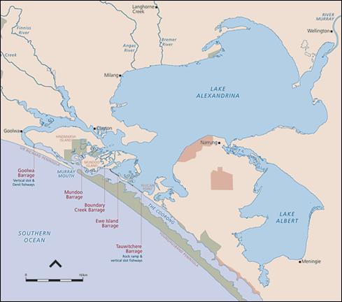
3.208
Since then, a total of five barrages have been constructed: Goolwa,
Mundoo, Boundary Creek, Ewe Island and Tauwitcherie. They separate the lakes
from the Coorong, the Murray Mouth and the sea (see Figure 3.6).
3.209 The MDBA's
submission states that a drought in the early 1900s was the catalyst for the
construction of barrages, due to lower flows down the Murray River:
By 1902, during a
major drought, there were already signs that the estuary was being affected by
reduced freshwater flows.[142]
3.210 This was
compounded by increased water use upstream, leading to reduced flows of fresh
water in the lower lakes. This in turn impacted on the communities and
industries, mainly agricultural, around the lakes. The SA government sought support
to build the barrages to reduce the ingress of salt water into the lower lakes
and provide fresh water security.
3.211 The MDBA stated
that during the construction of the barrages salinity in Lake Alexandrina was
higher than in the ocean, so the decision was made to create a freshwater lake
system rather than for the lakes to become hyper-saline more frequently:
In 1938, shortly
before the barrages were finished...the salinity at Milang on the western shore
of Lake Alexandrina peaked at more than 60,000 EC, which is saltier than the
ocean. Governments were faced with a choice of either building the barrages to
create a freshwater lake system or allowing the lakes to experience increasing
periods of hyper-salinity.[143]
3.212 MDBA's factsheet
also notes that aside from supporting the local farming community, the eventual
goal was to ensure a freshwater supply to Adelaide:
After construction of
the barrages, South Australia finally had the confidence to connect Adelaide's
water supply to the River Murray downstream of Lock 1.[144]
Water levels and quality in the
Lower Lakes and Coorong
3.213
Water levels and quality in the Lower Lakes and Coorong have changed
over time. They have been particularly affected by local weather, fresh and
salt water flows, water extraction, and evaporation. The MDBA's submission
indicates that salinity levels in Lake Albert and the Coorong in particular are
'mainly dependent on fresh water flows to South Australia and local weather.'[145]
3.214
The MDBA's submission acknowledges that there is a 'variety of views' on
the water type, levels and quality in the lakes prior to European settlement.
However, the submission contends that historical evidence demonstrates that the
lakes were predominantly fresh:
Historical material
from the 1800s (including stories from the Ngarrindjeri people, explorers’
diaries, information from sealers and herdsmen and parliamentary submissions by
settlers) shows that the Lower Lakes were mainly fresh.[146]
3.215
The submission also seeks to support this hypothesis stating that
scientific evidence (though not referenced) confirms that the lakes were
predominantly fresh:
Microscopic analysis
of single-celled algae (Diatoms) also provides evidence that in the 7,000 years
since they were formed, the Lower Lakes would have been mainly fresh with rare
seawater inflows.[147]
3.216
The MDBA does however note that in times of low river flow and high
evaporation, it is likely that sea water would have flowed into the lakes:
It is likely that
when river flows were very low, there would have been areas around the Murray
Mouth and towards Point Sturt in Lake Alexandrina where sea water would have
flowed back into the lakes.[148]
3.217
This would have resulted in 'periods of elevated salinity in the lakes.'
However, MDBA notes that this would have been an irregular occurrence.[149]
3.218
The committee heard conflicting evidence on this matter. Dr Jennifer
Marohasy, Spokesperson, Myth and the Murray Group, argues for the removal of
the barrages, stating that the lakes were originally estuarine; that is, a mix
of salt and fresh water. She referred to a map of the region produced after
explorer Charles Sturt's first trip along the Murray River, indicating that the
map characterised Lake Alexandrina as estuarine:
...it clearly shows the
headwaters as fresh and most of Lake Alexandrina as brackish. Then you can see
that about a quarter to a third of Lake Alexandrina is described as comprising
salt water. This map, as I said, was drawn in 1839. ...it was an estuary—salt
transitioning to brackish transitioning to fresh...[150]
3.219
One witness at the Goolwa hearing, did however state that his family's
farm, close to the Murray Mouth and its main channel, had been able to draw
fresh water from that end of the lakes for generations. Mr Colin Grundy,
Director, Mundoo Pastoral Company Pty Limited, stated that his family had
farmed in the area since 1876, using water for stock from creeks that ran from
the lower end of the lakes onto Mundoo Island.[151]
3.220
Mr Grundy, like MDBA, also attributed the change in the composition of
the lakes prior to the barrages as being due to lower flows coming down the
Murray River into the lakes:
The thing that has
changed from 1876 is there is not as much water coming down the river. We have
got weirs, locks and everything that was put up the river. The barrages were
the last thing put in I understand. So that is what has changed. The water flow
is not coming down.[152]
3.221 It would appear
from this and other early accounts that Lake Alexandrina and Lake Albert had
varying degrees of salinity depending on the season and weather patterns
consistent with a natural large estuarine environment.
Water security
3.222
Mr Neil Shillabeer, private capacity, stated that some irrigators rely
on the lakes for water as they do not have the option to draw water from a
pipeline:
The irrigation
pipeline that comes to this area on the western side of the lakes is a private
line. It is a corporate line that has been paid for by irrigators. There is no
irrigation line on the eastern side of the lakes—Lake Albert and the eastern
side of Lake Alexandrina. It was looked into through the drought and the cost
was found to be astronomical with the volumes of water that were
necessary—tenfold volumes of water for the type of irrigation required in those
areas than what we have on this side of the lakes. The argument about a
provision of irrigation water in lieu of quality lake water is only applicable
at this point in time for the western side of the lakes system.[153]
3.223
Changes to the use of water along the Murray River and its tributaries,
together with the addition and/or removal of structures to manage water have
affected the flows and composition of the water in the lower lakes. These have
also had an impact on evaporation from the lakes.
3.224
Presently, in addition to persistent calls to alter the freshwater state
of the lakes, there are two more minor adaptions to flows that may impact water
quality in the Lower Lakes and Coorong – the current South East Flows
Restoration Project, and the potential for a connector between Lake Albert and
the Coorong. These are discussed in greater detail following the sections
below.
Evaporation from the Lower Lakes
and Coorong and salinity issues
3.225
Evaporation from the Lower Lakes has been an issue of contention
throughout the inquiry. Many submissions, particularly from upstream water
users, expressed frustration at water being sent down the Murray River only to
evaporate from the lower lakes. This sentiment was particularly expressed when
a submitter’s water access had been reduced as a result of the plan. Closely
tied to the issue of evaporation was the issue of salinity.
3.226
Mr Stan Dineen, a witness at Broken Hill, estimated the level of
evaporation in the lakes to be approximately 750GL per year.[154] Cr Terence Hogan,
Chairman, Riverina and Murray Regional Organisation of Councils (RAMROC),
stated that the evaporation from the lakes was counterproductive and was
removing water from productive use elsewhere in the basin:
If we are challenged
to increase food and fibre not only around the world but in this country, how
can you afford, as I said, to have up to 1,000 gigalitres of water just
evaporate annually?[155]
3.227
Further, Mr Ken Jury, a witness at Goolwa, stated that evaporation rates
vary depending on the weather and estimated that the water that evaporated
during drought years was worth millions of dollars:
Of course in a
drought they are going to be a lot more. I know in the millennium drought the
figure of 1,150 gigalitres was floating around. In non-drought years it is
something like 840. They are a bit flowery, but it is in that region. It is a
variable system, as someone just said. If you rounded the figure for the Lower
Lakes alone I would be quite happy and quite comfortable in saying it was worth
$7 billion during the millennium drought.[156]
3.228
Furthermore, some witnesses noted that evaporation of salt water leaves
an increased salinity problem, so if the lakes are more saline environmental
issues would become more complex:
...the evaporation rate
means that, if you put salt water in, all you are left with is an increased
salinity problem, so we cannot have that.[157]
3.229
Mr Colin Grundy, Director, Mundoo Pastoral Company Pty Limited, stated
that salt levels have devastating impacts on farmers. Mr Grundy recalled the
last drought and the impact it had on the stock on his property, which is right
at the mouth of the Murray:
The salinity levels
rose so much that the water was useless for our stock, for irrigation and for
environmental purposes. The water level dropped two metres below the normal
pool level, 1.5 metres below sea level, exposing acid sulfate soils, turning
backwaters into battery acid and killing all that came in contact with them.[158]
3.230
Mr Grundy also stated that the highly saline water had a severe impact
on the environment:
We still had rain in
this area, so we had feed for our cattle, but no suitable drinking water. With
low water levels and the saline water the environment dried up and died. Things
were dying all around us. We suffered large stock losses due to the high saline
water.[159]
3.231
Indeed, the committee heard of similar impacts during the millennium
drought that were experienced right through the basin.
3.232
Salinity is particularly an issue in the southern lagoon of the Coorong.
Mr Garry Hera-Singh, Chairman, Southern Fishermen's Association, stated that
sea water flow into the Coorong would not fix the salinity issue as it has a
high evaporation rate:
The evaporation rate
of the south lagoon—it is a long, shallow basin—is 85 gigs in a normal year. If
you get a hot year like the one we are about to experience, it will be 100 gigs
a year. It is like a dog chasing its tail. It is massive.[160]
3.233
On the other hand, water users around the Lower Lakes stated that fresh
water in the lakes was providing water for productive use as well as flushing
salt from the basin out to sea and keeping the mouth of the river open. Mr Bill
Paterson, Chairman, Coorong, Community Advisory Panel, stated that constant
freshwater flows (rather than large flood events) to the lakes are essential:
These freshwater
flows are essential to flush salt and nutrient from the entire river
system—and, as we have mentioned before, it is also important to keep the mouth
open. If you do not have a flow out, that mouth will silt up.[161]
3.234
The Department of the Environment provided responses to questions on
notice on this issue, and reiterated that the water is not just evaporating at
the end of the system:
One of the reasons
that some people continue to focus on the Lower Lakes is that they believe that
large volumes of water are being delivered just to the end of the river system.
This is incorrect.[162]
3.235
Rather, the Department reiterated that the water flowing down the river
provided benefits to the identified environmental sites prior to flowing into
the lakes:
The way the Basin
Plan was developed was to determine the environmental water needs of important
sites and functions over the length of the river system (from the top to the
bottom states). If all those sites and functions receive sufficient flows, then
there will be enough water travelling through to the end of the system. In
other words, if you meet all upstream environmental water needs then you will
also look after the Lower Lakes.[163]
3.236
However, the committee notes that meeting upstream environmental needs is
only one of the objectives of the Plan.
Ramsar listing of the Coorong and
Lower Lakes
3.237
The Ramsar Convention is the common name for the Convention on Wetlands
of International Importance. It is an intergovernmental treaty that provides
the framework for the conservation and use of wetlands and their resources.[164]
3.238
The Lower Lakes and Coorong area was listed as a Ramsar wetland in 1985.
At the time of the listing, an ecological character description was submitted,
which forms the baseline for measuring changes in the area.[165]
3.239
The lakes were listed as 'freshwater systems units', although it was
noted that salinity levels increased during periods of low flow.[166]
3.240
There are two key obligations for the Commonwealth with regard to Ramsar
sites. As explained by a representative from the Department of the Environment,
the federal government must promote conservation and report on any changes:
There are two
relevant clauses within the convention itself: article 3, which requires us to
promote the conservation of listed Ramsar sites, and article 3.2 requires us to
report any change in the ecological character that occurs as a result of human
induced interference. Then we put in a range of parameters, ...as to how we
measure that change. In essence, the site is listed in its state as at 1985 and
we would be required to report to the convention any change from that state to
the Ramsar Convention. They are the obligations that we have.[167]
3.241
The department's response to a subsequent question on notice stated that
changing the lakes from a freshwater system to an estuarine one 'would be
inconsistent with our international Ramsar Convention obligations.'[168]
3.242
Further, any proposal for changes to the freshwater nature of the
lakes—to an estuary or hyper-saline system—would trigger the provisions of the
federal environment legislation, the Environment Protection and Biodiversity
Conservation Act 1999.[169]
3.243
Mrs Sharon Starick, Presiding Member, South Australian Murray-Darling Basin
Natural Resources Management Board, emphasised the importance of Australia
meeting its Ramsar obligations with regard to the Coorong and Lower Lakes:
In terms of the Lower
Lakes and the Coorong area, they are critically important, not only for the
local economy that is based there, but also in terms of being a Ramsar listed
site, which means we actually have international obligations to deliver. That
does mean that, not only from South Australia's perspective, but also
nationally we have obligations in looking after those sites...[170]
3.244
Mr Neil Schillabeer, a witness at Goolwa, also noted the importance of
the Ramsar listing and the improvements in the region since the Plan commenced:
The Basin Plan, since
its inception in 2012, has already provided significant environmental
improvement in the region. The benefits of more consistent flows, due to
provision of environmental water, include improvement in salinity levels in the
lakes due to better salt export conveyance, improved salinity levels in the
Coorong by freshwater dilution, greater fish migration between river and sea
due to continual fish passage flows, provision of food that drives the fishery
and submerged vegetation and mudflat habitat—critical as a food source for
international migratory waders that rely on this extensive Ramsar site.[171]
Potential impact of removing or modifying
the barrages
3.245
Some witnesses advocated the removal of the barrages, or modifications
to some of the barrages, to make the lower lakes estuarine or to enable the
ingress of sea water during drought periods and the egress of fresh water to
flush the river during floods.
3.246
Dr Jennifer Marohasy, Spokesperson, Myth and the Murray Group, argued
that historically the lower lakes would have been naturally estuarine during
periods of extended drought. She stated that remains of sea creatures indicated
the presence of salt water in the lakes, particularly during periods of
extended drought:
Before the barrages,
during periods of extended drought, the entire lagoon would fill with sea
water. In 1914-15, the Southern Ocean pushed in, and right up at Wellington
there are reports of dolphins, sharks in Lake Albert, and even pygmy whales.[172]
3.247
Dr Marohasy called for a return to a tidal system:
...the restoration of
the Murray River's natural estuary, that the tide return and that the Southern
Ocean push in each autumn and for longer periods during drought. This would
truly represent a return of natural environmental flows.[173]
3.248
The MDBA's submission clearly stated that a natural estuary is not the
aim or intention of governments or the Plan. The submission stated that making
the Lower Lakes estuarine would severely impact the basin's irrigation industry
throughout the basin:
The only way that a
natural estuary could have been reinstated would have been to stop all
irrigation in the basin. That was not an option considered in the 1930s, nor is
it an option today.[174]
3.249
Some witnesses called for improved management of flows, including the
modification of some of the barrages. Mr Ken Jury stated that one way to
improve water management, flow and infrastructure would be to adapt some of the
barrages. Mr Jury called for the Goolwa barrage in particular to be adapted:
...[R]emove the Goolwa
Barrage stop-logs and replace them with full-sized, thick-walled polyethylene
tanks with a single pump to each. Current handling of single-concrete logs in each
bay is both cumbersome and outdated. Water delivery is slow and it can be
vastly improved...[175]
3.250
In concert with adapting the Goolwa barrage, Mr Jury stated that it
would be essential to reduce the size of Bird Island, a sand island located
close to the sea opening, which has grown significantly over time due to the
lack of tidal influxes. Mr Jury argued that the island is now so large that it
restricts the flow of water:
...[I]t will be
necessary to partially remove the obstructing Bird Island, previously a small
sandbar located in the Mundoo Estuary directly opposite the ailing Murray
Mouth.[176]
3.251 Other witnesses
were strongly opposed to the removal or modification of the barrages and the
ingress of sea water. Mr Neil Shillabeer stated at the Goolwa hearing that the
removal of the barrages would make the lakes hypersaline, and would have negative
environmental consequences for the lakes and the surrounding areas:
...within a period—I
said within 10 years—the lakes, if you remove the barrages, would go
hypersaline. That means not supporting any vegetation at all.[177]
3.252
Mr Shillabeer argued that removing the barrages was in direct opposition
to the Plan, and that therefore they should remain in place. However, Mr
Shillabeer stated that if the barrages were proposed to be removed, this should
be preceded by significant research on the consequences of the decision.[178]
Figure 3.7 Bird Island – Main Murray mouth channel[179]
3.253
Witnesses at Goolwa also emphasised the economic implications of
removing the barrages – both in terms of the ingress of sea water and the
fluctuation in water levels. Mr Thomas Chapman, Director, The Marina Hindmarsh
Island, stated that a tidal lake would impact on tourism and recreation,
particularly with regard to boating infrastructure:
Our infrastructure
was built for a pool level of 0.75 AHD. It is just slightly below that today,
to give you some idea. Changing this to a tidal facility would cost us millions
of dollars and there would be many other operators in the same situation. Many
of the boating facilities and destinations would no longer be available, the
tourist industry would be totally changed, there would be absolute quantum
change in where we go.[180]
3.254
The SA government also provided evidence on the damage that sea water
ingress might cause, stating that during the last drought this option was
considered:
Whilst considered as
a last resort option to manage acidification, the introduction of seawater
would have had significant, negative consequences including degradation of the
existing ecosystems, changing the ecological character of the Lakes. Adverse
effects on water quality at major urban, irrigation and stock and domestic
water supply off-takes below Lock 1 would have also needed to be addressed.[181]
3.255
The SA government stated that salt water was not required to flush the
lakes as trigger-levels for acidification were not reached.[182]
3.256
Irrespective of the merits of the arguments of those who oppose
returning the lower lakes to estuarine condition, the committee accepts that
removal or adaption of the barrages would require further work upstream to
protect the water supply for Adelaide and for other productive uses, including
irrigation and stock supply on either side of the lower lakes.
Potential construction of a lock at
Wellington
3.257
One issue, raised repeatedly by submitters and witnesses, was the
potential for an additional lock on the Murray River before it enters Lake
Alexandrina. A possible location for this lock was at or near Wellington, SA.
3.258
This lock was called Lock Zero by submitters and witnesses, and was
often mentioned in the context of removing the barrages (thus enabling the
ingress of sea water), as a way to protect water supply for Adelaide and
productive use below the existing Lock 1 at Blanchetown, SA.
3.259
Some witnesses argued that a lock at Wellington would ensure fresh water
supply for Adelaide and other downstream uses, while also enabling the Lower
Lakes to be open to the sea. Mr Jury, a witness at Goolwa, stated that if the
barrages were to be modified, a lock would be required at Wellington to
conserve fresh water for productive use. Mr Jury thus called for the
construction of Lock Zero at Wellington:
...[L]ocate one more
river lock, recognised locally as lock zero, to be placed upstream of
Wellington and to be founded on recognised friction piling...[183]
3.260
Similar views on the need for an additional lock were heard upstream. In
Griffith, Mr Ronald Pike, stated that an additional lock would increase the
water available for irrigators upstream:
What we can do is
return them to an estuarine development and build lock zero—which you have
talked about. We can make sure that we deliver the water to every single
present user and in a greater volume than they have now—we can do that
easily—and we can make sure it is at the right price. When we do that we have
around a million megalitres of extra water back upstream.[184]
3.261
Mr Neil Eagle, a witness at Echuca, also argued in favour of Lock Zero.
Mr Eagle stated that a location slightly upstream of Wellington might be more
suitable for locating the lock, but argued that advanced engineering should
make building a dam on unstable soil feasible:
I do not know the
South Australian areas well, but as I have had it explained to me there is a
solid base in an area that is upstream of Wellington, but regardless of that,
apparently, and I am not an engineer, with friction piling it can be built in
unstable soils anyway, so it is nonsense that we cannot build a dam—or a
reservoir!—somewhere near Wellington. It can be done, engineering-wise. With
the new technologies now that is not a problem.[185]
3.262
Other witnesses indicated that a weir at Wellington would not be
feasible as the river bed would not support such a structure. Mr Adrian
Pederick stated that he had argued against the proposal during the last
drought:
There was talk of the
infamous Wellington weir, which I railed against and the community railed
against, which was a $200 million proposal that would have sunk because they
sounded it when they built the other structures in the river.[186]
3.263
The practical difficulty in building a lock at Wellington was also
covered by the MDBA. Mr David Dreverman, Executive Director, River Management
Division, MDBA, stated that a site for a permanent weir below the offtake for
Adelaide's water could not be found due to the nature of the river:
They looked for a
permanent weir site back in 1930s and did not find one, and we did not find one
again in 2007-08. The river there is very deep—it is 17 metres deep—and it is founded
on very soft, unconsolidated estuarine sediments.[187]
3.264
The SA government stated that a temporary weir near Wellington has
always been 'a measure of last resort' and that the government did not want to
construct a weir 'unless it was absolutely necessary to protect the State's
potable water supply.'[188]
3.265
Furthermore, the MDBA and the Plan do not support the construction of an
additional lock or the return of the lower lakes and Coorong to an estuarine
state.
3.266
While an additional lock might enable greater active management of water
below the lowest existing lock, it might have the potential to impact on water
users downstream. Cr Keith Parkes, Mayor, Alexandrina Council, stated that the
construction of a lock at Wellington would degrade the system and reduce or
stop primary production downstream, and suggested that this would replicate the
existing situation in future:
So let's block it off
at an imaginary lock at Wellington, degrade the water in this part of the
system and pump a bit more water out further upstream so that we can irrigate
and grow more food while the food down here dies. After we have had a few years
of going gung-ho at that, as we have been doing in the past, let's kill the
next pond and go to Blanchetown and then start again beyond that.[189]
3.267
Cr Parke did not elaborate on how or why such degradation would occur.
3.268
The committee did however, receive evidence from Mr Peter Fraser,
Manager of McConnell Dowell Constructors (Aust.) Pty Ltd in South Australia,
who stated that its subsidiary company Built Environs had been involved
in the construction of the Hindmarsh Island Bridge, and reconstructing several
of the Murray River weirs and fishways during SA Water’s campaign to upgrade
and enhance those facilities. It stated that 'In relation to constructing a
permanent weir near Wellington we confirm this is technically feasible'. Mr
Fraser stated that an earth fill weir/lock structure could be developed for
approximately $50 million at the site of lock zero near Wellington.
Committee view
3.269
The committee is cognisant of the complex interrelationships between the
Murray River, the Lower Lakes, the Coorong, and other water bodies and aquifers
that discharge at the end of the Murray-Darling Basin. Further, the committee
is aware that changes to one part of the system can have sometimes unexpected
impacts on other parts of the system. Accordingly, any changes should be
approached with caution preceded by careful evidence-based research to
ascertain the social, economic and environmental impacts of the proposed change.
3.270
With regard to the Coorong, Lower Lakes and Murray Mouth region, the
committee notes the view of witnesses who demonstrated that the area was
historically estuarine and had been altered by the construction of the
barrages. A prime example of change since the construction of the barrages is
the growth of Bird Island, the sand bar that has silted up the mouth of Murray
River.
3.271
The committee also notes the changing water levels and water quality in
the region, and the varying evaporation rates and salinity levels from these
bodies of water during different times of the year.
3.272
The committee does not accept arguments that returning the lower lakes
to estuarine condition, assuming there is a lock at Wellington to prevent the
upstream movement of brackish water during periods of low river flow, would
necessarily have negative implications for current water users in South
Australia.
3.273
The committee considers there is potential for enormous environmental,
social and economic benefits to upstream communities as a result of returning
the lower lakes to estuarine condition.
Recommendation 11
3.274
The committee recommends that Bird Island be removed by the South
Australian Government and MDBA to improve water flow through the Murray mouth.
Recommendation 12
3.275
The committee recommends the MDBA calculate the economic value of fresh
water evaporated from the lower lakes.
3.276
The committee is of the view that the Lower Lakes and Coorong are
wetlands of international importance, and as such should be managed in
accordance with the principles of the Ramsar Convention. However, the committee
is of the view that the Ramsar listing of the Coorong as freshwater is
inconsistent with historic and current salinity levels. As such the committee
considers that a detailed study be undertaken to inform a reassessment of the
Coorong's Ramsar classification.
Recommendation 13
3.277
The committee recommends the government undertake a detailed study to
inform whether a reassessment of the Coorong's Ramsar listing from a fresh
water system to an estuarine system is more appropriate.
3.278
Given the historically estuarine environment, the committee sees value
in assessing potential options for the removal of some or all of the barrages
or adopting adaptive management of the barrages to allow the ingress of salt
water during periods of low flow.
3.279
The committee is of the view that returning the lakes to an estuarine
environment may have significant benefits by allowing more water upstream to be
utilised for productive agriculture and environmental watering, as well as
reducing the loss of fresh water through evaporation in the lower lakes.
3.280
The committee considers that these benefits should be quantified in
order to determine whether removal or alterations to the barrages would provide
the most productive use of the fresh water in the basin.
3.281
The committee notes evidence that this could have negative effects on
Lower Lake irrigators, landholders and the environment and recognises these
aspects should be taken into account. Landholders who require fresh water for
stock, irrigation or other productive use should be adequately serviced by
fresh water, through pipes or other means of supply, sourced sufficiently
upstream to ensure it remains fresh.
3.282
Furthermore, should a greater estuarine environment be assessed as
positive, the committee would support the construction of a lock where the
river enters Lake Alexandrina to secure fresh water supply to towns, irrigators
and landholders.
3.283
The committee is aware that these potential changes would constitute a
major alteration to the Plan and the current understanding of the way the
system operates. However, the committee sees value in assessing the potential
costs and benefits of these options.
Recommendation 14
3.284
The committee recommends the government undertake cost-benefit analyses
of the following options for adapting the management of the Lower Lakes and
Coorong, and their social, economic and environmental impacts throughout the
basin:
-
removing all of the barrages;
-
removing some of the barrages;
-
modifying some of the barrages (such as Tauwitcherie and
Mundoo);
-
allowing the ingress of salt water into the Lower Lakes during
periods of low flow; and
-
investigating the construction of an additional lock at a
location above Lake Alexandrina, such as near Wellington, SA, either in concert
with the above options or as a single change.
3.285
Should such analysis indicate that one or more of these leads to
more positive social, economic and environmental outcomes than the current
basin plan, the committee recommends the Plan be amended accordingly.
South East Flows Restoration
Project
3.286
Historically, fresh water from the south east region flowed into the
southern end of the Coorong then in a north-westerly direction. Prior to
European arrival the area behind the Coorong, the 'interdunal' corridors, were
swamps that feed groundwater and drained into the Coorong from the south east
through Salt Creek.[190]
With the
establishment of the SE Drainage Scheme during the 20th Century, the
inter-dunal corridors were released for grazing and cultivation and huge areas
of wetland habitat lost or radically altered. At the same time numerous
drainage outlets cut through the coastal region to the sea: these were
significant modifications to the coastal geomorphology of the region.[191]
3.287
Dr Jennifer Marohasy stated in her submission that this land was
progressively drained from the 1860s to the 1970s and has meant that 4000GL of
fresh water has been diverted from the Coorong through drains and floodways to
the sea:
What those drains did
was redirect that water, so now it goes straight out to sea. So 4,000
gigalitres of water is now going straight out to sea—water which once flowed
into the Coorong—down the Coorong and then out the Murray Mouth. What happened
was that drainage programs drained the underground aquifers.[192]
3.288
The SA Government's response to questions from the committee outlined
that various programs have been undertaken in recent years to divert flows back
into the Coorong.[193]
3.289
One of these programs is the South East Flows Restoration Project
(SEFRP), a $60m investment by the Commonwealth and SA governments to 'assist
salinity management in the Coorong South Lagoon, enhance flows to wetlands in
the Upper South East and reduce drainage outflow at Kingston beach.'[194]
3.290
The project will use a variety of channels to divert water to the
Coorong to reduce salinity:
Using a combination
of natural watercourses, newly constructed flood ways and existing drains, the
South East Flows Restoration project aims to divert additional water from the
Upper South East into the Coorong South Lagoon to help provide environmental
benefits that would assist in maintaining a healthy South Lagoon ecosystem
through lower salinity.[195]
3.291
The project's design and survey, environmental program, cultural
heritage program, land acquisition, community engagement and program management
aspects have all commenced and are ongoing or in progress. Construction
delivery is scheduled to commence in spring 2016.[196]
3.292
Restoration of fresh water flows to the Coorong was supported by various
witnesses in South Australia. Professor Peter Gell, Professorial Research
Fellow, Federation University Australia, stated that the Coorong is a naturally
highly tidal system that 'would have received considerable volumes [of water]
from the
south-east', in addition to tidal inflows from the north.[197]
3.293
Professor Gell stated that historically, this combination of salt and
fresh water inflows from different locations has been sufficient to keep the
salinity level of the Coorong below that of the sea:
...the Coorong was not
more saltier than the sea; it was always less saltier than the sea and has as
little as a 10th of the salinity of the sea. So there must have been a
considerable volume coming from the upper south-east. With our work, we cannot
reconstruct how much. Certainly for most of its time, it was around half the
salinity of seawater, so there must have been a considerable shandying effect
from the water from the upper south-east.[198]
3.294
Professor Gell stated that the Murray River itself has not generally
contributed to the flows in the Coorong as it flows directly out to sea when
the river floods:
There were times when
the river water may have contributed but, by and large, typical of estuaries,
the river Murray goes straight out over the top when it is in flood and it does
not contribute significantly to the Coorong.
In fact, we found
next to no river Murray algae in the Coorong record for the whole of the last
7,000 years.[199]
3.295
Mr Grant Rigney, Board Secretary, Ngarrindjeri Regional Authority, also
concurred that change is required to the bottom half of the Coorong, stating
that it is very saline at present:
Set some change to
the bottom half of the system; it is super saline on the moment.[200]
3.296
However, Mr Paul Harvey, Member, River Murray, Lower Lakes and Coorong
Tourism, Boating and Environmental Group, stated that while fresh water inflows
from the south are important, they also need to be complemented by fresh water
inflows from the northern end of the Coorong. Mr Harvey stated that the SEFRP
project on its own will not have a significant impact on the health of the
Coorong:
Management of the
South Lagoon in the long term will require both that project and river flows
going in through the North Lagoon of the Coorong. They are both essential but
the south-east drainage project does not really make a significant difference
in terms of the amount of water, in fact it makes virtually no difference in
terms of the amount of water that is still needed in the Murray River system to
be able to manage the South Lagoon of the Coorong.[201]
Lake Albert-Coorong Connector
3.297
There is no direct flow of water between Lake Albert and the Coorong.
Both bodies of water are separately connected to Lake Alexandrina. As
highlighted earlier, freshwater was discharged in the top north eastern end
while water was flushed in from the Murray mouth end. However, the southern end
of Lake Albert, west of Meningie, is only separated from the Coorong by a few
kilometres of land.
3.298
Witnesses at the South Australian hearings discussed the possibility of
a connector between Lake Albert and the Coorong. Councillor Neville Jaensch,
Mayor, Coorong District Council, stated that a connector would improve flow
between the two lakes:
The Coorong connector
is basically to allow flow from Lake Albert to the Coorong. It is a very short
distance between the two at a certain point. The fact is that you have water
coming in one end and it cannot get out the other.[202]
3.299
Mr Hugo Hopton, Regional Manager, South Australian Murray-Darling Basin
Natural Resources Management Board, concurred, stating that the possibility of
a connector had been discussed for some time, and would provide much better
connectivity between the two bodies of water:
...the connection
between the bigger lake, Lake Alexandrina, and Lake Albert is very restricted,
so it is very hard to get water exchange. That is the premise behind it—trying
to get some through-flow.[203]
3.300
Ms Caren Martin, Chairperson, South Australian Murray Irrigators, stated
that the connector would benefit communities, irrigators and the environment:
It is triple bottom
line. We in society want it, irrigators want it and the environment needs
it—because, again, the do-nothing scenario in the northern south lagoon of the
Coorong is not an option. It is dying.[204]
3.301
Mr Hopton noted that a connector, whether a channel or a pipeline, would
need to be effective, so it would be imperative to ensure the connector would
function well. Mr Hopton noted that one of the biggest issues is the velocity
of the water travelling through the connector:
The wind action
brings a lot of sand into suspension and when the water slows going through the
interconnector the sand can sediment and it is very difficult to clean it out.[205]
3.302
Mr Hopton also noted that there were significant cultural heritage
issues depending on the location of the connector:
There are also
significant cultural heritage issues to with the range of alignments that have
been discussed.[206]
3.303
Cr Jaensch argued that the Lake Albert scoping study options paper,
which showed that the connector would be relatively uneconomic, did not measure
all the benefits of the connector.[207]
Cr Jaensch argued that a feasibility study would assess broader benefits:
The amount of local
pressure that we have and the fact that, irrespective, the movement of the
water is of benefit. The other aspect I am aware of anecdotally is that, if
water is released into the Coorong at the correct time of the year and in
reasonable volumes, it promotes fish spawning and other things in that respect.
So it does have other economic benefits to the region.[208]
3.304
Further, Mr Samuel Dodd, Chairman, Meningie and Narrung Lakes Irrigators
Association, stated that the benefits of a connector to irrigation on the
Narrung Peninsula would be minor and a side benefit, compared to the benefit to
the environment. Mr Dodd argued that the primary benefit and intention of the
connector would be to improve the environment:
...increased production
from the limited irrigation industry on the Narrung Peninsula. That is actually
a gain from the Coorong connector, rather than the primary function of it. The
primary function is for environmental outcomes. ...Our five-point plan was an
environmental plan that would give economic irrigation spin-offs, not the other
way around.[209]
3.305
Many witnesses called for further investigation of the feasibility of a
connector. The SA government's submission stated that options for a connector
pipe or channel had been explored 'to address water quality issues and maintain
ecological health.' The submission noted that the options assessed were 'not
considered suitable for various reasons, including cost and failure to maintain
the ecology of the site.'[210]
3.306
Furthermore, the SA government's submission stated that the costs of a
connector would outweigh the benefits:
Modelling and
engineering studies have found that the costs of connecting infrastructure
between Lake Albert and the Coorong outweigh the benefits. In addition, with
predicted Basin Plan environmental flows, it would not be needed to return Lake
Albert salinity to its historical salinity range.[211]
3.307
The SA government's submission indicated
that water cycling is currently taking place to improve salinity levels, and
temporary pumping could be undertaken in future if required:
Instead, the South Australian
Government is cycling water levels in the Lower Lakes to remove higher salinity
water from Lake Albert. Temporarily pumping water between Lake Albert and the
Coorong could be considered if needed in a future extreme drought.[212]
3.308
Mr Dodd, however, argued that past lake cycling had actually increased
salinity in the lakes. Mr Dodd also stated that a recent CSIRO report had also
confirmed this:
The reality is that
it actually increases salinity. They trialled it in the 1980s. Rather than
helping and being of benefit it increased salinity. We got a report in the last
week from the local environment department in relation to another issue, which
is a CSIRO report that they use for management of the Lower Lakes, and it
clearly states that, if you drop lake levels, you bring saline water from
groundwater into the lakes. It is actually getting the exact opposite to what
they are trying to achieve.[213]
Committee
view
3.309
The committee supports the South East Flows Restoration Project and
urges the SA government to accept more responsibility for the environmental
state of the Coorong. The committee encourages the SA government to implement
management practices to improve the environmental state of the Coorong.
3.310
The committee heard evidence that a connector between Lake Albert and
the Coorong has the potential to improve the flow of water between these two
bodies, and that a connector would benefit the environment. The committee notes
that some studies have already been undertaken into the feasibility of a
connector; the committee supports an independent feasibility and hydrology
study of a connector, including environmental and economic costs and benefits,
as well as a study into the current practice of lake cycling.
Recommendation 15
3.311
The committee recommends the government commission an independent
feasibility and hydrology study into a connector between Lake Albert and the
Coorong to assess the environmental and economic costs and benefits of the
connector, and compare this to the current practice of lake cycling.
Other matters
3.312
Two other key matters arose during the inquiry: foregone agricultural
production due to the implementation of the Plan, and the Snowy Mountains
Hydroelectric Scheme.
Foregone agricultural production
from implementation of the Plan
3.313
One of the indirect impacts of the implementation of the Plan is
foregone agricultural production. Farmers and irrigators whose access to water
was reduced under the Plan (or who must buy water from the trading market and
are therefore subject to significant price fluctuations) are often unable to
grow the same type, quantity or quality of crops, thereby reducing the volume
and value of agricultural production in some regions.
3.314
It can be difficult to quantify the
effect of a single factor such as the Plan on an industry that is affected by
multiple factors. It can also be difficult to distinguish foregone agricultural
production as cropping mixes and farming practices change over time.
3.315
In addressing the issue of the impact of the Plan on agricultural production,
an official from the Department of Agriculture (now the Department of
Agriculture and Water Resources) stated that there are many factors that affect
agricultural production:
...the Basin Plan, the
weather, international markets, the price of the dollar and the price of farm
inputs, the value of agricultural production in the basin has been increasing
and the total amount of production has continued to increase. The other thing
that also makes that difficult is that there have been changes in cropping mixes
as people have moved from rice to cotton, for example, and there are changes in
the efficiency of water use by farmers.
3.316
The Department indicated that despite varying local conditions and
multiple factors, including the Plan, the value of agricultural production has
continued to grow:
It is quite a complex
story but, to date, the value of production has continued to increase as a
result of a whole range of factors. We cannot separate out the Basin Plan's
impact or role as opposed to anything else. But as the Basin Plan was part of
the overall Water Initiative, as we discussed earlier, the capacity for
security entitlements and the trade of water has underpinned some of the
development growth.[214]
Dairy
3.317
The increasing cost of water has also had an impact on the Australian
dairy industry, which is a $13 billion farm, manufacturing and export industry.
It is the largest irrigation based livestock industry in the Murray-Darling
Basin, with around 1790 dairy farms producing 27 per cent of the Australian
milk supply.
Ninety eight per cent of these farms are family owned. There are 31 large and
small milk-processing facilities providing manufacturing jobs for thousands of
Australians.[215]
3.318
Dairy farmers not only rely on water to irrigate pastures used for milk
production; water is also a necessity for fodder supplies and agistment.
Overall, a lack of water and/or a lack of affordable water has meant that milk
production is no longer growing, despite the potential to grow substantially
over the next decade as a result of growing export markets. The Australian
Dairy Industry Council (ADIC) indicated that:
Milk production is
significantly constrained compared to pre-drought levels. Production has not
recovered but has now levelled out at below pre-drought levels.[216]
3.319
ADIC stated that although it supports the objectives of the Plan, the
slow recovery of the milk production industry does appear to be due to the
Plan:
The dairy industry in
the Murray dairy region, which incorporates southern New South Wales as well,
before 2007 was producing an average of 2,800 megalitres of milk a year. After
2007 that went down as consequence of the drought, and it bottomed out at about
1,870 megalitres a year. Since then we have managed to recover back up to
2,300, but in the last three or four years we have seen that we are basically
plateauing out at that level of milk production, and that seems to be the Basin
Plan effect: without access to more water or water affordability or a very
large change in farming production systems, or both, we are not going to get
back to where we were pre-drought.[217]
3.320 Mr Paul Ingleby,
director of Australian Consolidated Milk spoke of the uncertainty created by
continuing loss of available water:
We have a joint
venture with Freedom Foods in a UHT dairy plant that we have invested $65
million in in the last couple of years. We employ more than 70 people. We
have significant investment opportunities for these operations in northern
Victoria, but these plans are now on hold until the availability and
sustainability of water in the region is assured.[218]
3.321
Further, in the Goulburn-Murray irrigation district, reduced production
is due to the sale of high-reliability water entitlements to the Commonwealth:
...dairy farmers in the
Goulburn-Murray irrigation district have sold 120 gigalitres of
high-reliability water entitlement to the Commonwealth. An additional 289
million litres of milk could have been produced if those entitlements were
still owned by dairy farmers, worth $144 million at the farm gate and $360
million in regional economic activity. This forgone production is not being
offset by increased production or investment in other primary industries, so
the effects will be long term.[219]
Food processors
3.322
This inability to produce crops and goods also has a secondary impact on
food processors, which are unable to maximise production due to this supply
constraint. Thus the reduction of water has considerable flow-on effects in the
economy and the community.
3.323
In the food processing sector, Kagome Australia is a tomato grower and
processor:
...Kagome Australia is
probably the most IT-enabled and most advanced tomato grower on the planet. We
have advanced technologies that our competitors right around the world do not
have. We produce product that we believe is world-class. We have invested about
$150 million in this area and, since March, we started a new business in food
service.
...[W]e have recently
stopped being a seasonal business, endeavouring to be a year-round business by
starting a carrot and beetroot business.[220]
3.324
Kagome Australia's CEO stated that its existing processing plants
currently have capacity for additional production:
Without putting in
any more installation and just having our existing operation, we could probably
put on another 30 per cent. We have already almost tripled in the last three
years.[221]
3.325
This constraint is due to business risk factors, significantly, the
availability and affordability of water.[222] Further significant
expansion of food processing in northern Victoria is also stalling due to this
constraint.
Committee view
3.326
The committee acknowledges that there are many factors that influence
agricultural production. However, the committee contends that foregone
agricultural production can be directly attributed to the implementation of the
Plan.
3.327
The committee is of the view that any foregone agricultural production
from the implementation of the Plan, and the subsequent impacts on businesses
and communities, is a significant issue that needs to be quantified and
addressed so as to reduce or reverse any negative effect the implementation of
the Plan has on such areas.
Recommendation 16
3.328
The committee recommends the government direct the
Productivity Commission to investigate the value of foregone production and
food processing due to reduced irrigation water under the Plan.
Snowy Hydro
3.329
The Snowy Mountains Hydro-electric Scheme (commonly referred to as Snowy
Hydro) is a hydro-electric power scheme that collects and stores water that
would normally flow east to the coast. The scheme diverts this water through
trans-mountain tunnels and power stations and into the Murray and Murrumbidgee
Rivers for irrigation.[223]
3.330
The scheme is operated and maintained by Snowy Hydro Limited, and
comprises sixteen major dams, seven major power stations (two underground), a
pumping station, 145kms of inter-connected trans-mountain tunnels and 80kms of
aqueducts.
3.331
In addition to generating renewable energy, the scheme diverts water
that underwrites over $3 billion in agricultural produce.[224]
3.332
The Commonwealth Parliament established the Snowy Mountains
Hydro-electric Authority in 1949, which was the operating body of the scheme.
In 1997, the NSW Government and State Electricity Commission of Victoria
established Snowy Hydro Trading Pty Ltd (SHTPL), a joint venture to trade
electricity generated by the scheme in the National Electricity Market. The
Commonwealth became a shareholder in early 2000.[225]
3.333
In 2002, the Snowy Mountains Hydro-Electric Authority was corporatized,
which resulted in the merger of the Authority and SHTPL to become Snowy Hydro
Limited.[226]
3.334
A key priority for Snowy Hydro Limited is to balance and meet the twin
needs of irrigation and renewable energy production, noting that it is
currently not part of the Murray-Darling Basin Authority's remit.
3.335
The scheme diverts a significant volume and value of water to
irrigation, which enables substantial agricultural production. The operation of
the scheme can therefore have a major impact on agricultural production and on
the levels of water in the Murray and Murrumbidgee Rivers.
Committee view
3.336
Given the high demand for both irrigation water and renewable energy,
the committee is keen to ensure that the operation of the scheme meets the
needs of the Australian community.
3.337
The committee is of the view that the scheme should seek to properly
balance the priority of irrigation and energy production, and give effect to
local and downstream social, economic and environmental considerations.
3.338
The committee is cognisant of the fact that the seasonal timing of water
releases by Snowy Hydro is of vital interest to irrigators, and notes
suggestions that the timing of such releases could be managed to better suit
irrigators without adversely affecting the broader operations of Snowy Hydro.
Recommendation 17
3.339
The committee recommends that the government assess the operation of the
Snowy Mountains Hydro-electric Scheme to determine the priority of irrigation
and energy production.
Recommendation 18
3.340
The committee recommends the operation of the scheme be assessed, and
adjusted as required, to give more effect to social, economic and environmental
considerations of local and downstream communities.
Navigation: Previous Page | Contents | Next Page